Following the Federation of Australia in 1901, a stipulation was to form a ‘Territory for the Seat of Government’ which had to have access to the sea for the purpose of establishing a sea port for the country’s capital. This provision was finally formalised in the July of 1915. The processes leading to the ‘Jervis Bay Territory’ Surrender and Acceptance Acts of 1915′ were described:
” . . . the establishment of the Federal Capital is the accepted policy of the King’s Government in Australia, and one Cabinet after another has dealt with the project. Contemporaneous with the discussion of the creation of a Federal Territory and a Capital City the opinion was expressed that the National Capital should be served by a national port. Obviously in carrying out the duties that were intrusted to us under the Federal Constitution it was necessary that we should look at the proposed site of the Federal Capital from the point of view of the future possibilities of a port. As honorable members will understand, owing to the position of the Federal Territory itself, attention had to be turned in another direction, and after somewhat extended negotiations the Federal port of Jervis Bay was created. An Act which was assented to on the 20th February, 1915, was passed by the New South Wales Parliament, providing for the surrender to the Commonwealth of the Territory at Jervis Bay . . . “
Source: Excerpt – Shoalhaven Telegraph (NSW) – Article ‘Jervis Bay Territory Acceptance Bill’ – published 14th July 1915
An overview of the evolution of the process is summarised below:
1900 – Commonwealth of Australian Constitution Act 1900 (UK)
Section 125 of the Commonwealth of Australian Constitution Act 1900 (UK) allowed for the Federal Capital of Australia to be allocated a territory. It was to be located within within the state of New South Wales, not less than 100 miles (161 km) from Sydney and of a size of not less than 100 square miles (161 sq km).
1904 – Seat of Government Act
In the ‘Seat of Government Act 1904‘ the Commonwealth of Australian Constitution Act 1900 (UK) was updated to include new locality parameters, the valuation of land rules, as well as an increase in the size of the territory to 900 square miles (2,331 km²). It also stipulated that the territory have access to the sea as national and international transport via waterways was still the most efficient at the time:

1915 – Jervis Bay Territory Surrender & Acceptance Acts
Following the establishment of the ‘Territory for the Seat of Government‘ in 1911, access to the sea and the establishment of a sea port was still pending. Jervis Bay was the chosen location and consequently the outlined area was released by the New South Wales government via the Seat of Government Surrender Act (NSW) – Act 9 of 1915 on the 20th February 1915 – assented to on the 1st March 1915.
The Jervis Bay Territory Acceptance Act – No 19 of 1915 dated the 8th July 1915 was assented to on the 12th July 1915, and hence, the ‘Jervis Bay Territory’ was established. The newly formed territory encompasses an area of some 67.8 km²:
” . . . The State shall surrender to the Commonwealth, and the Commonwealth shall accept, the territory (hereinafter called the territory), now being part of the State, described hereunder, namely : –
All that piece and parcel of land and water situate at Jervis Bay in the Parish of Bherwerre, County of St. Vincent, State of New South Wales, Commonwealth of Australia, area about 18,000 acres, commencing at a point on the high water mark on the left bank of Sussex Inlet at its intersection with the western boundary of portion 12 of 40 acres and bounded thence westerly and north-westerly by that high water mark to the high water mark of St. George’s Basin, thence in a general easterly and north-easterly direction by that high water mark to its intersection with the production westerly of the southern boundary of portion 18 ; thence easterly by a straight line formed by the western production of the southern boundary of portion 18, the boundary itself, and its production easterly to the high water mark of Jervis Bay ; thence by a line across the southern part of Jervis Bay bearing north-easterly to a point in the high water mark of Jervis Bay at the northernmost extremity of Bowen Island ; thence by the high water mark of Jervis Bay and of the South Pacific Ocean along the eastern boundary of Bowen Island to the southernmost point thereof ; thence by a line bearing south-westerly across the passage between Bowen Island and Governor Head to the high water mark of the South Pacific Ocean on the foreshore of the mainland, at the northernmost point of Governor Head ; and thence by that high water mark in a general southerly and south-westerly direction to St. George’s Head ; thence in a general northerly, westerly, and south-westerly direction by the high water mark of Wreck Bay to the high water mark on the left bank of Sussex Inlet before mentioned ; and thence in a general northerly direction by that high water mark to the commencing point . . . “
Source: Excerpt – Jervis Bay Territory Acceptance Act 1915 – assented to on 12th July 1915
The ‘Jervis Bay Territory’ is located approximately 200 km East of Canberra, 190 km South-South-West of Sydney, and, 830 km North-East of Melbourne – by road.
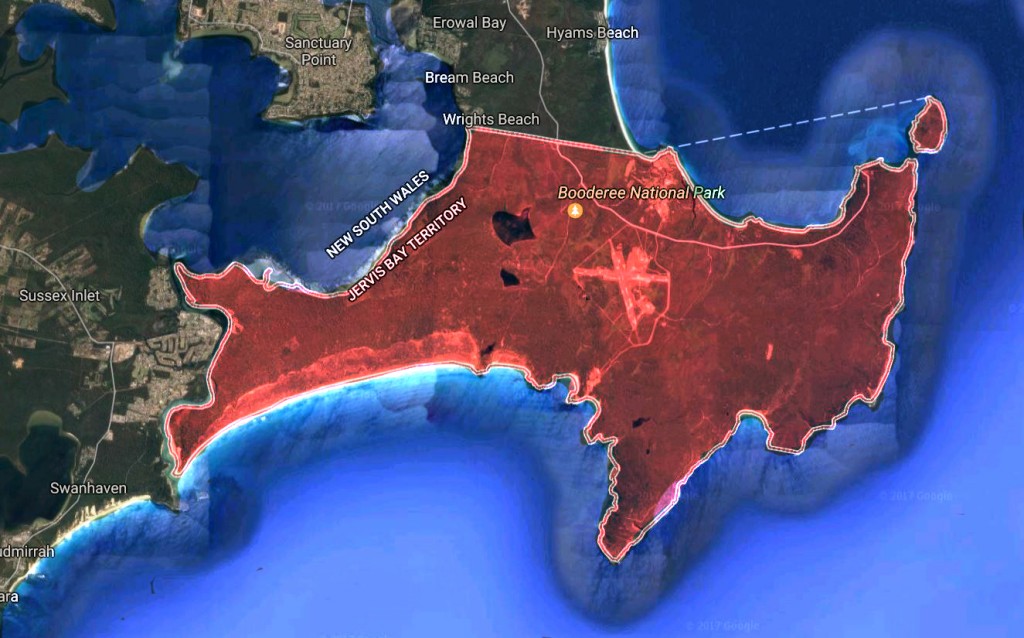
The Territory is not self-governing and though it is technically not a part of the ‘Australian Capital Territory’, the laws that govern the ‘Australian Capital Territory’ also govern the ‘Jervis Bay Territory’.
View other important events in Australia’s History . . .
View other important events in New South Wales’ History . . .
View other important events in Australian Capital Territory’s History . . .
