Longitude: 147.726801 Latitude: -37.920267
Metres above Sea Level: 7.2 m
Area: 25.4 km² Perimeter: 23.9 km
View Raymond Island’s Statistics & Demographics
.
Raymond Island is accessed via ferry from Paynesville. A relatively small island of some 6 km in length and 2 km in width, the island has materialised due to millennia of repeated sea level rises, and falls – occurring during various glacial periods. As sea levels rise, the ocean pushes the sand inland thereby filling river mouths and forming a barrier to the sea.
Today, this barrier is known as the Ninety Mile Beach, which was formed approximately 20,000 years ago.
Raymond Island is a remnant of a more ancient barrier known as the ‘Prior Barrier’. An inner barrier formed sometime later, and then finally, approximately 75,000 years ago, a fall in the sea level altered the river paths, cutting the ‘Prior Barrier’ and thereby forming Raymond Island. A combination of coastal sands and alluvial soil deposits created the top soil strata that supports the varying woodlands and habitats that we see on the island today . . .
As Europeans began infiltrating Gippsland in the early 1840’s, explorers and settlers carved trails through the unforgiving terrain. Parties were sent to survey and document this vast new area. One of these parties was led by John Reeve, who departed the township of Sale in 1842 to identify, name and chart Gippsland’s lakes, lands and rivers. Reeves named Raymond Island after William O’Dell Raymond and McMillan Strait, the body of water that separates the island from the mainland, after Angus McMillan.
Today, the expansive lake views from the island encompass the mountains to the north, the sand dunes of the Ninety Mile Beach to the south, and, the seaside village of Paynesville to the west. Much of the island remains uninhabited providing a sanctuary for native flora and fauna.
A wonderful way of exploring the island is by foot or via push bike. If you leave the car behind, the short trip across McMillan Strait on the ferry is free !! The varying sceneries of jetties, parks, farms, bush, sandy beaches and stunning water views will delight. The peace and serenity of the beaches, parks and bush are not to be missed.
Kangaroos, Koalas and Bird Life abound.
Refreshments are available from the abundant choise of cafes and restaurants located along the waterfront, upon your return to Paynesville.
The debate of a ferry service vs a bridge has been ongoing. Technically speaking, a ferry service has been in existence since the very first Aborigine crossed McMillan Strait in a bark canoe some 20,000 years ago. The tradition lives on !!!

Raymond Island Ferry Boat – Ferryman Standing whilst rowing
The first European ferry boat arrived in mid 1888. It was small, hence demands for a punt continued. By late 1889, the Raymond Islanders enjoyed their first punt service, however it was to be short lived. Following complaints received from the ferryman, the Shire Engineer withdrew the service of the relocated river punt by early 1890.
Four years were to pass before a punt service was reinstated.
It was soon recognised that a purpose built punt was required for the job. A new wooden punt sporting Oregon beams and a Kauri Pine deck – measuring 12.2 m in length and 4.3 m in width, commenced service in 1901. The ferry straddled chains running along both sides and was driven by a hand-wheel winching system. Ferry Jetties and Sheds were built on both the mainland and the island to ensure the comfort and accessibility of the passengers. The 1950’s saw a passenger cabin fitted to the punt, and, both the punt and ferryboat were motorised.

Raymond Island Punt c 1910
The wooden punt serviced the McMillan Strait crossing for 68 years. The 1960’s saw the old punt sink a number of times and hence the ‘Elliott Ferry’ was commissioned – with its first official crossing taking place on the 6th March 1969.
At 18.6 m in length and 11.6 m in width, the new ferry was one third longer and two thirds wider than the old wooden punt that had served for so long . . . Its six car capacity was increased to eight vehicles by re-positioning the swing gates over the flaps in 1984. Three years later it was modified to increase the vehicle capacity to ten.
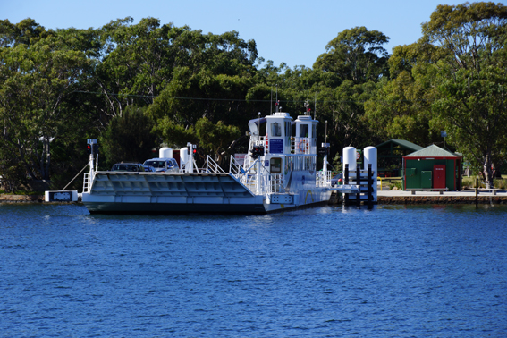
The Raymond Island Ferry – today . . .
Increased demand saw the present day ferry evolve. Sporting a Passenger Deck, a capacity to carry 18 to 21 vehicles, and, registering in at a size of 34.5 m in length (almost twice the length of the previous ferry) and 11 m in width – the twin chain, diesel powered ferry carries some 500,000 passengers and 250,000 vehicles annually.
From the first lease of land awarded to Patrick Cody in 1856 – to the very first pioneer, Uriah Hoddinott, to establish a residence in 1874 – to the plans of establishing a township in 1884 – to the first school enrollments of 1902 – to the introduction of the island’s Koala population in 1953 – to the establishment of town water in 1963 and electricity in 1964 – to the island community and tourists that can still enjoy the tranquil, stunning and natural beauty of Raymond Island today.
Plan your trip to Raymond Island here
Discover Raymond Island via POI Australia’s Interactive Map,, or, acquaint yourself with
– Shopping
– Services
.
.
Epilogue:
POI Australia has been designed to network Australia by encouraging and harnessing local knowledge wherever possible.
Our aim is to –
– encourage locals to support LOCAL community groups and events; and to use LOCAL products and services
– encourage visitors, tourists and investors to the many amazing regions of Australia that are so often overlooked.
During our visit, we have endeavoured to capture the essence of Raymond Island and collectively, with our research, have summarised the Points Of Interest (POI) that we have found.
We know that there are many more POI and stories to tell. We enthusiastically invite and encourage contributions to POI Australia – no matter how large or small. To submit information regarding your town and region, please contact us. The information will be reviewed, edited (to suit the segment), approved and added to POI Australia. Remember: “a picture says a thousand words” – so the more photos – the better. To maintain relevancy of the information on the website, we are always grateful to receive updates at any time.
We encourage community organisations, sporting clubs, events, non-for-profit organisations to list with us, as all these services are totally free of charge – apply for your 100% Discount Coupon here.
In order to maintain the free community services, POI Australia provides an opportunity for businesses to support their town and region by advertising for a nominal annual fee. The business listings are designed to be very quick and easy to complete, providing links to existing websites, Facebook, etc., so that time-poor business owners can quickly add and maintain their listings. We hope that the low charges will encourage business to “spread the word”.
The more we network, the more successful we will be in promoting Australia’s locations, stories, histories, businesses, people, sustainability and the environment.
Working together, we can protect our Country, our Environment and our Communities . . .

Raymond-Island-125-Small

Raymond-Island-053-Small

Raymond-Island-090-Small

Raymond-Island-105-Small

Raymond-Island-050-Small

Raymond-Island-139-Small

Raymond-Island-131-Small

Raymond-Island-137-Small

Raymond-Island-061-Small

Raymond-Island-065-Small

Raymond-Island-083-Small

Raymond-Island-091-Small

Raymond-Island-095-Small

Raymond-Island-102-Small

Raymond-Island-106-Small

Raymond-Island-112-Small

Raymond-Island-116-Small

Raymond-Island-129-Small

Raymond-Island-145-Small

Raymond-Island-150-Small
