” . . . The Lady Nelson, under Lieutenant Murray, was the first ship to enter the bay of Port Phillip. On 5th January 1802, Mr. Murray was driven from the Heads by a storm, after having noticed that there was a practicable entrance. Mr. Bowen, his mate, however, safely entered in the vessel’s launch, and the ship was able to follow on the 15th of February. The flag of the old country was hoisted on the 9th of March, when Mr. Murray took possession on behalf of his Majesty George the Third. Governor King named the bay Port Phillip, and the rocky point on the east side of the entrance Point Nepean . . . “
Source: Excerpt – ‘Illustrated Australian News’ – Article “A Holiday Tour Round Port Phillip” – published 18th December 1886
Port Phillip Bay is a large, natural inlet on Victoria’s southern coast on which the capital city of Melbourne lines the northern shores of the bay. It covers an area of approximately 1,935 sq km (480,000 acres) – its coastline stretching some 265 km. The entrance that joins Bass Strait to Port Phillip Bay is known as The Rip – it is an extremely narrow and dangerous stretch of water requiring the expertise of Sea Pilots to guide the ships of yesteryear and the massive ships of today through safely.

The Valley of Port Phillip & the course of the Yarra River c 18,000 years ago – Extract – ‘The Geology & Geomorphology’ – Series 8 – by Eric Bird
Port Phillip Bay is unusually shallow for such a large expanse of water which provides many challenges for ships. Rather than following a straight line to the sea ports of Melbourne, ships are forced to follow a channel, where once the Yarra River flowed, in a time where sea levels are estimated to have been some 140 m below the level they are today. The old Yarra basically ran directly south from Melbourne until approximately Rosebud, where the channel turns sharply westward and deviates through the ‘Port Phillip Heads’ i.e. ‘The Rip’. Massive sandy and muddy shoals stretch across the Bay meaning that some 50% of the bay registers depths of less than 8 m – the deepest point being only some 24 m, however, there is a section within ‘The Rip’ that plummets to a depth of approximately 95 m – adding to the impact of the volatility of this stretch of water . . .
Port Phillip Bay has provided seaside life, holidays and recreation for almost two centuries. Beautiful seaside villages line the shores, enjoying the stunning and ever changing views and ambiance that the Bay bestows. Summer sees boats of all sizes come out to play – sailing, kayaking, powered, jet skis – fishing remains ever popular – as does sunbathing, strolling, relaxing on the sand, swimming in the relatively safe waters of the bay as well as wind surfing, paddle boarding, kite surfing . . .
A wonderful playground located right on the doorstep of Victoria’s capital city of Melbourne.
.
The Evolution of Port Phillip Bay – an Overview . . .
The following extract provides a short summation of the evolution of Port Phillip Bay:
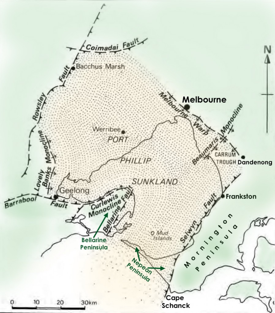
The Port Phillip Sunkland – Extract – ‘The Geology & Geomorphology’ – Series 8 – by Eric Bird
” . . . The Bay occupies part of a fault-bounded structural depression, known as a “sunkland” between Rowsley Fault, to the west, and Selwyn Fault, to the east. Within this area, the Earth’s crust has subsided intermittently to form a broad lowland, the north-western part of which has been covered by volcanic lava to form the basalt plain between Geelong and Melbourne, while the south-eastern part, submerged by the sea, forms Port Phillip Bay. The southern part is constricted on the western side by the uplifted Bellarine Peninsula, and on the eastern side by the Nepean Peninsula, an area of accumulated dunes, partly consolidated into dune sandstones. The eastern side is made up of the Mornington Peninsula, an uplifted area of geological complexity, and Carrum Swamp, which occupies a broad depression between Frankston and Mordialloc. In the north-east there is a slightly uplifted sandy plateau between Beaumaris and Brighton, declining northward to the Yarra valley . . . “
Source: Excerpt – ‘Structure & Surface – The Geology & Geomorphology of the Sandringham District’ – by Eric Bird – published 1990
.
The Impact of Increasing the Size of ‘The Rip’
‘The Rip’ has been blasted since the 1860’s in order to enlarge the narrow passage between Bass Strait and Port Phillip, thereby decreasing the risk of ships coming to grief on the underlying reefs:
“A TERROR REMOVED.
The Port Phillip Rip.
Since 1903 the officers of the ports and harbours branch of the Public Works Department in Melbourne (says the “Age”) have been at work widening the channel through the Rip, which is one of the terrors to passengers and navigators in and out of Port Phillip. In order to make the channel perfectly safe for two large vessels to pass it was decided to increase the 37 feet waterway by 500 feet, giving a passage of 2,200 feet. During the past seven years 150 tons of gelignite and blasting gelignite have been used in clearing away the rocks in the vicinity of the Lonsdale reef. Though the blasting work has been completed, surveys have yet to be made to make perfectly certain that no pinnacles have been missed. By the autumn it is expected that a full fairway will be made available to navigators. The work, which has been supervised by Mr. T. H. Smith, the marine surveyor, has cost to date about £20,000.”
Source: The Brisbane ‘Telepgraph’ – published 12th January 1910

The Age – 6 Jul 1939
It is interesting to consider that all this dramatic blasting has been occurring within two between two roughly parallel faultlines that run on either side of Port Phillip Heads – the ‘Selwyn’s Fault’ located some 22 kms to the east, and, the ‘Bellarine Fault’ only 5 km to the west . . .
Another such occasion was reported in 1923:
” . . . According to Queenscliff fishermen, between 40 and 50 large schnapper had a few whiting were picked up by men in surf boats immediately after a blasting charge had been exploded in the Rip on September 26 . . . “
.
” . . . It is asked by the fishermen that blasting should not be carried out in each year during October and November when fish come into the bay. They point out that the steamer Rip, besides blasting, does the buoying in both Port Phillip and Westernport Bays, in addition to other work, and they suggest that needless destruction would be avoided if the department could keep her solely to that work during the spring months. Early in the year, fishermen approached the department which agreed to meet the request so far as was possible. It was pointed out yesterday that the Rip has not done any blasting so far this month. It was engaged all last week in buoying. But it is not considered practicable wholly to suspend blasting in the spring. The work which has been carried out continuously for many years, except in bad weather, is to widen and deepen the entrance to the bay. It is regarded by the department as of the utmost importance that it should be carried on speedily . . . “
Source: Excerpts – ‘Argus’ – Article “Blasting in the Rip. – Are Fish Destroyed! – Report to be Obtained” – published 9th October 1923
The blasting and dredging of ‘The Rip’ has continued, increasing its depth from some 9 m when the first explorers discovered Port Phillip to over 20 m to this current day. The most dramatic works of more recent times was during the 2008–09 channel deepening and widening project at which time ‘The Rip’ was blasted yet again and immense dredging works were carried out along the channel, into the Yarra River and the ports of Melbourne. An estimated 3 million tonnes of toxic and contaminated sediment from dredging the Yarra during the channel deepening project was dumped in the middle of the Bay. Though environmental reports warned of the probable repercussions to the Bay – the works went ahead, despite public outcry.

Portsea Front Beach c 2016
The result has been a noticable increase in the water level of Port Phillip Bay, dramatic erosion all around its coastline including the widely publicised loss of the beautiful, sandy front beach at Portsea – which has now been replaced by rocks and sand bags in a vain attempt to hold back the sea . . .
These works were carried out to accommodate the ever increasing size of ships – the result for Port Phillip Bay is irreversible. The narrow ‘Rip’ had maintained a tidal range of around 1.1 m within the Bay, even though the tidal range in Bass Strait is more like three times this figure. It was feared that increasing the channel depth would increase the volume of water in the Bay – and that is exactly what has happened.
Further fears that the blasting has removed the hard rock layer and possibly revealed the relative soft lime stone layer thereunder – which could potentially open the way for increased erosion of ‘The Rip’ channel and therefore result and even more dramatic changes to the seaside villages that line the shores of Port Phillip Bay, have not yet been confirmed.
The environmental changes to Port Phillip Bay over the past 180+ years of European occupation has been so rapid and dramatic that it cannot be ignored. Sandy beaches are being washed away, cliff faces are eroding right before our eyes . . .
.
Signs of Times gone by . . .
Travelling around the shores of Port Phillip Bay, old jetty pylons dot the shoreline reminding us of the romantic and beautiful era of the elegant steam ships that once plied these waters on a daily basis, conveying passengers and cargo across the Bay. Today not one steamer remains – imagine what a delight historic paddle steamer tours would be for tourists to the Bay . . .
Incidentally, the skeleton of the PS ‘Ozone’ wrecked at Indented Head defiantly prevails.
Though much of the past has been lost, some of the beautiful, historic buildings and infrastructure built by the very first pioneers have been saved. Ever popular with tourists, it is hoped that the monuments and remains will continue to remind us of the beginnings of European occupation in the area. The explorers, the pioneers . . .
The first to venture into Port Phillip Bay were Lieutenant Murray, and some 10 weeks later, Matthew Flinders:
.
January 1802 – Lieutenant John Murray & Crew on H.M. Survey Vessel ‘Lady Nelson’
The following extract is a transcript of Lieutenant Murray’s journal during his time in Port Phillip:
” . . . On leaving King Island, Murray, on January 30th (civil time),* [* In this chapter civil time is given in the author’s observations. The time in the logs throughout is according to nautical reckoning, i.e. the day beginning at noon before the civil reckoning.] returned again to Western Port and next day, at 4 A.M. he sent Mr. Bowen with 5 men in the launch to examine the harbour to the westward which is now known as Port Phillip and at the head of which stands the city of Melbourne. On Wednesday the launch returned and the first mate reported that he had found a good channel into the harbour which was “a most noble sheet of water.” He also reported that he saw no natives but only their huts. Shortly afterwards Murray himself entered the newly discovered Port in the Lady Nelson.
Murray arrived there on February 14th and anchored at 3.30 P.M. in a sandy cove off a point of the shore which lay distant a quarter of a mile to the south-west. He named a high mountain Arthur’s Seat; a cluster of islands where black swans were plentiful Swan Isles; a bold rocky point to the east-south-east Point Paterson and a long sandy point Point Palmer.
The chart of Port Phillip (Illustration 11) is possibly a reproduction of the track of the Lady Nelson’s boat when the bay was explored for the first time. Arthur’s Seat and Watering Place apparently are the only names placed on it by Murray* [* It is preserved at the Admiralty.] as Swan Pond and “Point Repear” are in a different handwriting. At “Point Repear” the long boat of the Lady Nelson may have been repaired or the name may have been written in mistake for Point Nepean, also named by Murray.
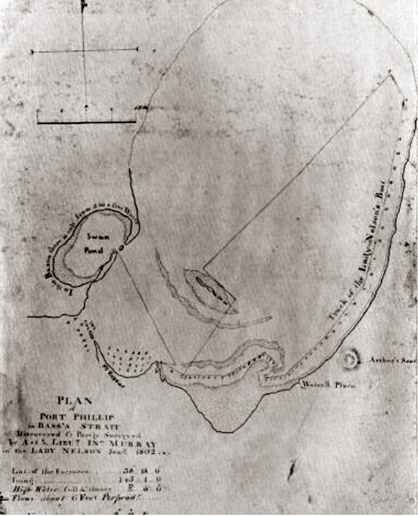
CHART OF PORT PHILLIP SHOWING THE TRACK OF THE LADY NELSON’S BOAT IN 1802 In this chart by Murray, sent to the Admiralty from Sydney by Governor King in 1802, few names appear, although Murray named Point Palmer, Point Paterson, and Point Nepean, and the fact that it bears the date January 1802 seems further evidence that it is the first chart of Port Philip drawn by its discoverer. It is one of those referred to as “unfortunately missing” in the Historical Records of New South Wales volume 4 page 764.
The following entries describe his coming to Port Phillip.
“Wednesday, January 27th. From noon till 8 P.M. variable winds, hot sultry weather, dull fiery sky and so thick that we could not see above a mile ahead; kept making for Cape Albany (Otway). At 8 short sail and hove to…at 4 A.M. the wind settled into a westerly gale attended with heavy squalls and rain. By 9 A.M. it turned into a clear gale and a very high sea up which makes us labour a good deal. Had altitude longitude by then 143 degrees 13 minutes 40 seconds, these agree with the dead reckoning within 3 or 4 miles. Latitude 39 degrees 12 minutes 33 seconds. This weather has again rendered abortive my plan of getting the direct line of bearing and distance between Cape Farewell and Cape Albany Otway. I shall only observe that I never experienced such length of bad weather at any time of year or in any country since I sailed the seas.
“Saturday, January 30th. At half-past 9 A.M. the north point of land bore north distant 12 miles–made sail for it. At 10 A.M. perceived with surprise that it was Cape Shanks and Grant’s Point instead of Cape Albany. I now judged it prudent to send our boat down to overhaul for a channel into the harbour mentioned in the Log of the 5th of this month, accordingly stood in for it and by noon Cape Shanks bore north-west distant 6 or 7 miles and Grant’s Point north-east by east 10 or 11 miles. We had a very heavy swell and perceived the surf about Seal Islands breaking in a fearful manner; sounded every hour.
“Sunday, January 31st. At 2 P.M. passed Seal Island. Observed the long range of breakers on the western side of the Port: several of them had shifted their berths nearer to mid channel…the whole of them for several miles broke incessantly and remarkable lofty–we passed within 2 miles of them. The reefs on the eastern side also broke much further out. In short the mid channel up this port has (by the immense run of bad weather) been made narrower. By 5 P.M. got to anchor in Elizabeth’s Cove…out boats. Got the launch ready for sailing in the morning to explore the channel of the western harbour before mentioned. I went on shore in the gig. Found the well as we left it full of fine clear water and our board of directions hanging at the entrance of the pathway. At 4 A.M.* [* It will be seen that Bowen left to explore Port Phillip at 4 A.M. of January 31st and not on February 1st.] I sent the launch with Mr. Bowen and 5 men armed with 14 days’ provisions and water down to the westward giving him particular instructions how to act both with respect to the harbour and natives should he fall in with any, the substance of which was that in finding a channel into the Port he would take marks proper for coming in with the vessel and immediately return to me and at all times to deal friendly with the natives. It may now be proper to observe that my intentions are that if a passage into that harbour is found I will take the vessel down into it and survey it as speedily as circumstances will allow, from that trace the coast to Cape Albany, from Cape Albany run strait to Cape Farewell and Harbinger Rocks, and if time, after that follow up the remainder of my orders.
“Monday, February 1st…A.M. I walked along the beach for 8 miles up to Lady Nelson’s Point and observed that a great variety of birds were in the brush and their notes very different; flights of white cockatoos of perhaps 100 were often seen. At Lady Nelson’s Point we saw 20 or 30 swans in the salt-water lagoon…one and all of the birds we have seen were so shy that…we did not shoot one (a single pigeon excepted). The trees also were all in bloom. I am apt to think that summer does not begin in this part till January. On penetrating further into this island the soil was found to be good.
“Tuesday, February 2nd. P.M. I sent a hand on shore to the well in order to see if any birds were to be got by his sitting there a few hours steady as numbers towards sundown came in to drink. The plan had the desired effect, 4 pigeons were shot, a dozen of parrots; these latter were common, I dined on them, the pigeons were preserved. On opening them all were found to feed on seeds of various kinds.
“Wednesday, February 3rd. P.M. As I was walking along the pathway to the well I nearly trod on a snake about 6 feet long, the first we have seen on the island. It made its way into the brush.
“Thursday, February 4th. Throughout these 24 hours we have had calms with hot sickly weather and thick fiery haze. At half-past 9 P.M. the launch returned on board, all well. Mr. Bowen reported that a good channel was found into this new harbour, water from 10 fathoms to 6 and about a mile and a half broad, and according to his accounts it is A MOST NOBLE SHEET OF WATER larger even than Western Port, with many fine coves and entrances in it and the appearance and probability of rivers, a number of shells were found on its beaches–swans, pelicans and birds of various sorts were seen in great numbers. The boat’s crew lived on swans all the time they were away.
“No water was as yet found–the officer having no time to spare, nor no natives seen but numbers of their huts, in short from such a report as I have received and of the truth of which I have no doubt (as the attention and care of this officer has always been conspicuous) it would be unpardonable in me not to give this new harbour a strict overhaul, in the meantime as it was calm and no appearance of getting out, at 8 A.M. hove up and towed the vessel up to Lady Nelson’s Point in order to send the boat up the river for birds such plenty of various kinds being on this island. At noon dropped our anchor in 6 fathoms, Lady Nelson’s Point bearing west by south half a mile and Crown Head 9 miles north-east by east and Margaret Island north-east ½ north 7 or 8 miles–moored with kedge.
“Friday, February 5th. Variable flaws of wind all round the compass this last 24 hours and hot sultry weather. Employed overhauling our bread which we found in good order. A.M. Sent the launch with the First Mate and 4 hands armed up the river to try and shoot some birds, it ought to be observed that the past two or three days we were here numbers of native fires were seen on the coast and up both arms, since then they have disappeared.
“Monday, February 8th. At 3 P.M. the launch returned, all well, having got a live swan, some dead ones and 4 crowned parrots, a single duck was shot. No fresh water was to be got even at dead low water and up as far as the boat could be pushed between the boughs of the fallen trees. At A.M. took up our kedge, weighed our anchor, made sail for Elizabeth’s Cove and at half-past 6 A.M. came to anchor…sent empty cask on shore to complete our water–also a party to cut wood, we filled our casks from this excellent spring. Longitude by chronometer 145 degrees 13 minutes 53 seconds.
“Tuesday, February 9th. Calm weather, constant thick fiery haze, very close and sultry. By 3 P.M. secured everything for sea intending to sail in the morning, took a haul of our seine, caught one whiting only and two remarkable curious fish.
“Wednesday, February 10th. P.M. Sighted our Bower anchor suspecting it to be foul, found it so. Having found a quantity of oysters, mussels and shellfish at low water to-day gave the shore a strict search at low water and plainly perceived that a company of 6 or 8 men would not run any hazard of being starved here for several months from the vast quantity of shellfish to be found. We also have these some days past found feeding on seaweed many hundreds of a very handsome shell very scarce where we were in April last.
“Thursday, February 11th. This evening a snake 6 feet long was killed in the road to the well.
“Friday, February 12th. A.M. Hoisted in launch, took up kedge intending to sail if wind came to anything, it however kept constantly falling calm and then a light air would spring up for a few minutes; this kind of weather obliged me to keep fast. At noon heard distant thunder around us.
“Saturday, February 13th. From 7 P.M. till 10 P.M. constant loud thunder, vivid lightning and very hard rain later part, till 9 A.M. Was calm then. A breeze sprung up at east. Hove up our B.* [* Bower, that is anchor.] and hung by the kedge, by this time it fell calm and our hopes of getting to sea vanished, needless to observe this kind of weather is as destructive to the intent of this cruise as gales at sea. I took a walk along the beach far enough to see all the entrances to this port and by ascending an eminence was confirmed in my opinion that several of those dangerous sand rollers had shifted their berths and by so doing had rendered the channel narrower than hithertofore.
“Sunday, February 14th…At 5 A.M. weighed and made all sail down the port, by 8 A.M. Grant’s Point bore east by north distant 10 miles and Cape Shanks north-west distant 7 miles; kept running down the land. A.M. At half-past 10 South Head of the new Harbour or Port north by east 8 miles distant; by noon the island at entrance of harbour bore north half a mile distant. At this time we had a view of this part of the spacious harbour, its entrance is wide enough to work any vessel in, but, in 10 fathoms. Bar stretches itself a good way across, and, with a strong tide out and wind in, the ripple is such as to cause a stranger to suspect rock or shoals ahead. We carried in with us water from 14 to 16 fathoms. Kept standing up the port with all sail set.
“Monday, February 15th. P.M. Working up, the port with a very strong ebb against us, we however gained ground. The southern shore of this noble harbour is bold high land in general and not clothed as all the land at Western Point is with thick brush but with stout trees of various kinds and in some places falls nothing short, in beauty and appearance, of Greenwich Park. Away to the eastward at the distance of 20 miles the land is mountainous, in particular there is one very high mountain which in the meantime I named Arthur’s Seat from its resemblance to a mountain of that name a few miles from Edinburgh…to the north-east by north, about 5 miles from the south shore lies a cluster of small rocky islands and all round them a shoal of sand; plenty of swans and pelicans were found on them when the boat was down, from which I named them Swan Isles. To the north-east by east there is an opening, and from our masthead no land could be seen in it. The northern shores are low with a sandy beach all along. At half-past 3 P.M. we got to anchor in a sandy cove in 7 fathoms water, bottom fine sand–Swan Isles bearing north-east by north distance 5 miles, a bold rocky point which I named Point Paterson east-south-east 1½ miles, a long sandy point named Point Palmer west, 1½ miles, and the nearest point of the shore south-west ½ of a mile distant.
“I went on shore and walked through the woods a couple of miles. The ground was hard and pleasant to walk on. The trees are at a good distance from each other and no brush intercepts you. The soil is good as far as we may be judges. I saw several native huts and very likely they have burnt off several hundred acres of ground. Young grass we found springing up over all the ground we walked; the only birds we saw were a few parrots. We found some shells on the beach and returned on board. I have named this harbour Port King* [* Governor King afterwards renamed the harbour Port Phillip in honour of the first Governor of New South Wales.] in honour of Governor P.G. King under whose orders I act. Set a third watch of the people with an officer. In the morning sent the gig to Swan isles for swans and on board we caught a few rock fish. At noon the gig returned with 3 live and 4 dead swans.
“Tuesday, February 16th. After dinner I took a walk through the woods of this part of the country, attended by one soldier and our carpenter to examine the wood. To describe this part I walked through is simply to say that it nearly resembles a walk on Blackheath and the Park if we set out of question the houses and gardens of the latter. The hills and valleys rise and fall with inexpressible elegance. We discovered no water nor any new wood of consequence, but it is impossible that a great want of water can be here from the number of native huts and fires we fell in with in our march. From the top of a high hill I ascended and casting my eyes to the north-east a large sheet of water was seen which I am inclined to think is either a harbour or large river; we also perceived that this port trained away under Cape Shanks.
“On our return to the boat Andrew Luck found a perfect nautilus shell; he made me a present of it, indeed it is but common justice to observe that the invariable good, attentive and decent behaviour of this old man ever since he joined this vessel renders him a fit object of mercy. This day a few snappers were caught and some rock fish. At sundown a native fire was seen about a mile inland, in the morning early I sent Mr. Bowen and Bond armed to speak them, neither fell in with them. At 9 A.M. hove up our Bower with a light air at north-east and dropped a few miles further up the Port. We now saw the same fire just lighted by the natives and presently perceived several of them come out of the Bush, but the moment they saw the vessel they sprang into the wood out of sight. At 11 A.M. we came to an anchor in 5 fathoms water, handed sails, etc., as there was a native fire burning a little way inland.
“I sent the launch with Mr. Bowen and 4 hands armed to see if any natives were here, and before the boat was half-way on shore we had the satisfaction of seeing 18 or 20 men and boys come out of the wood and seat themselves down on a green bank waiting the approach of our boat with which I had sent some shirts and other trifles to give them; the boat accordingly landed in the midst of them and a friendly intercourse took place with dancing on both sides–in an hour the boat returned. Mr. Bowen had dressed them in our white shirts and invited them on board, this however they declined, but exchanged for all this. Got a basket of straw neatly enough made. They were all clothed in the skins of opossums and each had a bundle of spears, a stone mogo and one basket. They wished much to know what our arms were and their use and did not seem entirely to believe Mr. Bowen that they were only walking sticks–no women were amongst them. I sent the boat again with some bread, looking-glasses, tomahawk and a picture as presents to induce them to part with their weapons and dresses as also to inform us where there was water. This day all hands put upon two-thirds allowance of bread.
“Wednesday, February 17th. Fresh light airs inclinable to calm throughout this 24 hours. The boat (as mentioned in latter part of yesterday’s log) proceeded to the shore and was as before received in a friendly manner by the natives, all of whom were seated in a circle on a beautiful spot of grass near a high point of land. Mr. Bowen and all the crew consisting of 5 men and the boy, Mr. Brabyn, went up with their dinners in their hands and sat down in the midst of them (18 in number) and began to eat showing the natives how to eat bread, etc., and gave them anything they chose to ask for. Mr. Bowen gave them all the things I had sent as well as several of his own things–stripping himself almost naked to comply with their wishes, and his example was followed by the whole of the boat’s crew. As there was two fine-looking boys amongst them I sent Mr. Brabyn on shore purposely to see and gain their confidence by his attention to their youngsters, both of whom he dressed in his shirts, handkerchiefs, trowsers, etc.
“All matters continued in this state while our people had anything to give and all we got was 2 spears, a basket and a mogo and even these they again took from the seamen that had them in keeping, this however the officer took no offence at being determined if at all possible to keep on friendly terms with them. It was in vain that the officer and crew tryed by signs too significant not to be understood to gain intelligence where water was to be found or on what beaches shells were most plentiful, to all such enquiries they turned a deaf ear and only seemed intent on getting what our people had even to the last shirt; by this time our people had nearly finished their dinners and Isaac Moss having the boat in charge got up and was walking slowly down to her. At this time the Boy Brabyn happened to turn his head towards the wood and saw a man in the very act of throwing a spear at Moss as well as a large body (not before seen) behind a large fallen tree with their spears all in readiness for throwing. The boy immediately cried out to Mr. Bowen who was at that very time in the act of serving out bread to all the party he was sitting among that he would be speared, but before the words were out of his mouth, a spear of a most dangerous kind, was thrown at and did not escape Moss by a yard and in an instant the whole of the treacherous body that Mr. Bowen and 4 of our people were sitting in the midst of opened out to the right and left and at once left them all open to the party in ambush who immediately were on their feet and began to throw spears; still such was the forbearance of the officer that only one piece was fired over their heads but this was found only to create a small panic, and our party were obliged to teach them by fatal experience the effect of our walking sticks.
“The first fire made them run and one received two balls between his shoulders, still some of them made a stop to heave; the second fire they all set off with astonishing speed and most likely one received a mortal wound. Before another piece was fired Mr. Bowen laid hold of one of their number and held on till three of our people came up and also grappled him, strange to tell he made such violent struggles as to get away from them all nor did the contents of the officer’s piece bring him up although one ball passed through his arm and the other in the side–he was traced a good distance by his blood–the remaining pieces were by this time fired and our party gave chase to them all.
“On board I kept a strict look-out with the glass and we lay only a little more than a quarter of a mile off the point where they were seated on. I plainly saw the natives running through the wood which was by no means thick–one fellow in particular had been dressed in one of my white shirts and the officer had tyed the wrists of it with string, which hindered his getting it off–him we plainly saw from the vessel pass the roots of black trees with such speed as more to resemble a large white bird flying than a man. To increase their panic as they passed along I gave them a discharge of our guns loaded with round and grape but am almost certain that they did them no damage; by this time our people returned from the chase, having found on the way back a number of spears, dresses and baskets, etc. Made the boat signal and they came off.
“Thus did this treachery and unprovoked attack meet with its just punishment and at the same time taught us a useful lesson to be more cautious in future. With respect to the size of these natives they are much the same as at Sydney, their understanding better though, for they easily made out our signs when it answered their purposes or inclination. When it did not they could be dull enough. They were all clothed in opossum skins and in each basket a certain quantity of gum was found. Not the least sign of a canoe has been seen. I conclude they live entirely inland, and if we may judge from the number of their fires and other marks this part of the country is not thin of inhabitants. Their spears are of various kinds and all of them more dangerous than any I have yet seen. The workmanship of their dresses, their lines and baskets are far from despicable, their mogo or stone axes are such as common at Sydney.
“In the afternoon the boat went to Swan Isles and caught three live swans of a large size, and in the morning the launch went with Mr. Power and a party well armed to sound for a channel round which the vessel might sail in order to survey the port. Usefully employed on board. Latitude 38 degrees 20 minutes south.
“Thursday, February 18th. Pleasant weather throughout. The launch returned having been fortunate enough to discover…fresh water and a channel all round this part of the Port from 10 to 14 fathoms. I took a long range through the woods attended with an armed party. We discovered nothing new but found several of the things we gave the natives which in their fright they had dropped. The ground we walked over was open and the same as before described, with good soil. The tide where we lie flows full and changes at 3 hours in the afternoon, and its perpendicular rise is about 6 feet up and down.
“Friday, February 19th. Another overhaul of the woods took place but nothing (not before mentioned) was found. Numbers of native tracks, fires and huts were seen. One native fire in sight on Arthur’s Seat distant about 10 miles.
“Saturday, February 20th. Sent an armed party and our carpenter a long range through the woods to try the different kinds of wood, none however was found of use, the trees being almost invariably oak and other wood quite common at Sydney. A red waistcoat of Mr. Brabyn’s was found with some bread in each pocket, in this he had dressed one of the native boys, who in his fear left it I fancy, as soon as he had found how to get it off, for it was buttoned on him.
“Sunday, February 21st. Finding we could not move higher up the port with the vessel I sent the launch over the western side to examine the passage into a harbour or river I saw from the hill on 16th inst.
“Monday, February 22nd. At noon the launch returned, having found an entrance into the sheet of water they were sent to overhaul, but only at high water, 7 or 8 feet of it, consequently no harbour for shipping. The boat proceeded a mile and a half, and, in running that, caught 20 swans of a large size without wasting one charge of shot, which by-the-bye is now become a scarce article, not above 3 or 4 pounds being in the vessel; however from the report made of this place it may lead to something of more consequence. I shall after the survey of the Port is completed give it a good overhaul. I must mention here that both our boats are now in such a state of decay from age and constant mending and patching that they both keep a hand constantly bailing when pulling or sailing, this circumstance it is needless to mention in a certain degree retards our proceedings.
“Tuesday, February 23rd. I went in the launch and sounded a few miles of the Port up towards the watering place. The soundings were 9 feet to 6 fathoms, bottom fine sand, further out perhaps a deeper channel may exist (this will be ascertained in the survey). Afterwards we walked through the country some distance, found the soil invariably good, the ground almost clear and the ranges of trees as regular as they are in general in the Park, with fine strong short grass underfoot.
“Wednesday, February 24th. First part of these 24 hours had a great deal of thunder and lightning and rain, middle and latter parts it blew a hard gale at south-west with squalls at intervals. We held on although all ataunto with the small bower and one-third of a cable out, a proof of the goodness of the holding ground.
“Thursday, February 25th. First part the gale continued, latter fair winds. Observed several very large native fires at the foot of Arthur’s Seat and on the western side of the port, hauled our seine several times along the shore nearest us but caught no fish owing probably to there being flats of sand lying off them to the distance of 200 yards.
“Friday, February 26th. Examined the beach and land for about 8 miles. A.M. Sent our long boat on shore, turned her up and set our carpenter to work on her, she leaking so much as to keep a hand constantly bailing, and our small boat is so bad as to render it hazardous to go any distance from the vessel in her.
“Saturday, February 27th. Fine weather and moderate winds. Both boats sounding and on survey of harbour. A number of very large native fires on the hills round the eastern and western shores of the Port have been seen these two days past. Sent Mr. Bowen and Mr. Brabyn in the gig to get the Latitude of the north end of Swan Isles and at noon I got the Latitude of a point about 7 miles North and South of them from which a base line was got for the survey of the harbour.

CHART OF BASS STRAIT, INCLUDING THE DISCOVERIES OF ACTING-LIEUTENANT JOHN MURRAY IN THE LADY NELSON, between November 1801 AND march 1802 By command of His Excellency Governor King. This chart, which bears Murray’s autograph, shows his explorations of Western Port, Port Philip, and King Island. It should be noted that Flinders’ Island is named Grand Capuchin. This is one of the charts referred to as “unfortunately missing” in the Historical Records of New South Wales volume 4 page 764. In this chart by Murray, sent to the Admiralty from Sydney by Governor King in 1802, few names appear, although Murray named Point Palmer, Point Paterson, and Point Nepean, and the fact that it bears the date January 1802 seems further evidence that it is the first chart of Port Philip drawn by its discoverer. It is one of those referred to as “unfortunately missing” in the Historical Records of New South Wales volume 4 page 764.
“Sunday, February 28th. Gave some of the people liberty on shore.
“Monday, March 1st. At 5 A.M. took up our kedge, hove short, loosed sails and sheeted home the top-sails, weighed and made sail up the port, intending to run as high as the watering place. The wind in a little time flied away and the tide ran so rapid as to sweep the vessel on a shoal of sand with only 5 feet of water on it, as it was perfectly smooth we immediately hove her off without her sustaining the least damage and dropped back into our old berth between Point Paterson and Bowen’s Point so named from Mr. Bowen’s skirmish with the natives in it. The flies are now so troublesome as to almost hinder a person from sitting a moment in one place.
“Tuesday, March 2nd. Employed getting on board stones for ballast and stowing them away. At 4 A.M. sent the longboat for a turn of water and to sound that part of the harbour between the vessel and it; by noon she returned on board with a turn of water, it was found that a bank of sand lay from shore to the distance of a mile or a mile and a quarter with only, 4, 5, 6, 7 and 8 feet on it at low water and it extends nearly 4 miles along shore. When you have passed this there is from 5 to 9 fathoms water abreast of the watering place, there is however little doubt of a deep channel being outside of this shoal, and this point will be ascertained in the course of to-morrow.
“Thursday, March 4th. P.M. The launch returned on board with a turn of water but had not been able to find a channel for vessel of any draught of water though she stood well out from the shore to at best 3 miles. This bank has only from 4 to 8 feet water on it and in many places is not above a hundred yards broad.
“Friday, March 5th. I went in the launch in search of a channel by which vessels of a larger draught than ours might be got up abreast of the watering place and was fortunate enough to find one a mile at least in breadth lying off the southern shores of this Port about 3 miles and having from 16 to 6 fathoms water in at low water and neap tides; and in this water a vessel of any draught may be secure from all winds at about a mile and a half from the spring at which to-day I loaded the boat with water and examined it. As far as we are judges it is most excellent water as clear as crystal–lies from the beach about 10 or a dozen yards and plenty of it to water the Grand Fleet of England; it is nearer the entrance than the foot of Arthur’s Seat by about 2 miles, and can easily be found out by the land which for a few miles before you come to it is low whereas all the other land on both sides is high with bold points; if a boat then East or east by south from Point Paterson 9 miles puts into the shore they will not be far off it, there is plenty of duck about it, but so shy that only two have been shot, a circumstance we did not a little regret as they exceed in flavour any I ever eat. We are now complete in water and will soon be wooded.
“Saturday, March 5th. Employed on board fitting new waist-cloths, the others being decayed and her sides and bends being very bare I gave them a coat of red (the only colour we had on board) and blacked the bends and upper works. A.M. I went in the launch over to the sheet of water* [* Mentioned on 22nd.] (as I intended) with an armed boat’s crew and by noon got to its entrance. This day has been so clear that we are able to see the land all round the Port and in many places very high headlands. In those low places, where we could not be certain of the land by the eye there were numerous native fires and some of them very large.
“Sunday, March 7th. By one P.M. I got into the sheet of water and by pulling all round it found it to be very extensive but, in no place more than 6 feet water and the greatest part of it so shoal as to ground the boat. In the entrance at one place there is a small channel of about 50 or 60 feet in breadth with 9 feet to 2½ fathoms water in, but of no use as it shoals to a couple of feet before you get in. The soil of the land all round the extensive place is good and its appearance exceeds in beauty even the southern shores. The number of large swans seen almost exceeds belief, but by this time most of them could fly, we caught 11–10 of which were large. All of us slept this night on a pleasant little island with a few handsome trees on it, soil good and so clear as to be fit for the hoe at once, I named it Maria Isle after a sister I lost some years past.
“Monday, March 8th. As we now intended sailing in a few days I judged it consistent with His Majesty’s instructions (a copy of which I was furnished with from the Governor and Commander-in-Chief of New South Wales) to take possession of this port in the form and manner laid down by the said instructions, and accordingly at 8 o’clock in the morning the United Colours of the Kingdoms of Great Britain and Ireland were hoisted on board and on Point Paterson, and at one o’clock under a discharge of 3 volleys of small arms and artillery the Port was taken possession of in the name of his Sacred Majesty George the Third of Great Britain and Ireland, King, etc., etc. Served double allowance of grog. In the afternoon I went on shore attended with an armed party and passed the remainder of the day about and under the colours flying on shore, at sundown hauled down the colours on board and ashore.
“Tuesday, March 9th. Employed getting ready for sea. Overhauled our keels fore and aft, cleaned them. We have now expended 19 weeks and one day’s provisions out of 24 weeks. We were victualled for commencing on 27th October 1801 and owing to the quantity of bread decayed, along with what the swans and other birds have eaten, we are rather short, even what we have left is very bad, therefore it will not be in my power at this time to prosecute the object of our cruise much further. It is in vain I regret so little being done in such a length of time, the weather and other circumstances have been rather against us the whole cruise, however the little that is performed of the original instructions is pretty accurate and I trust will give the Commander-in-Chief some satisfaction.
“Wednesday, March 10th. For these last two or three days great numbers of native fires have been seen all round the Port except between Arthur’s Seat and Point Palmer.
“Thursday, March 11th. At 7 weighed and made sail down the port by 8 A.M. with a strong tide of ebb running out we got into the entrance carrying all the way from 9 to 16 fathoms water, we then fell into such a ripple that we expected every minute it would break on board–got clear and by half-past the point of entrance bore north-east by east 4 miles and a remarkably high nob of land (if not an island) west-north-west 4 or 5 miles, by noon the entrance north-east by west 9 or 10 miles . . . “
Source: Excerpts – “The Logbooks of the Lady Nelson” – by Ida Lee – Chapter 6 – published 1915
.
April 1802 – Matthew Flinders R.N. & Crew on H.M. Survey Sloop ‘The Investigator’
Matthew Flinders accomplished the most amazing work of mapping Australia during the period 1795 to December 1803, when he was imprisoned by the French during a visit to Mauritius whilst travelling on the ship ‘Cumberland’. He was to remain a prisoner of the French until 1810 . . . His maps represent an accuracy that is only improved with the assistance of the satellites and computers of the modern age. Sir JK Laughton wrote in the Dictionary of National Biography:
” . . . Nobody can study Flinders’ beautiful charts without recognising them as the work of a master of his craft; and so well did he fulfil his promise, until the debility of his ship and a chain of misfortunes interposed to prevent him, that the Admiralty charts in current use are substantially those which Flinders made over a hundred years ago . . . “
Source: Excerpt – ‘Terre Napoleon – A History of French Explorations and Projects in Australia’ – by Ernest Scott – published 7th July 1910
The following extract is a transcript of Matthew Flinders’ journal during his time in Port Phillip, unbeknown to him at the time, just 10 weeks after Lieutenant Murray’s visit:
MONDAY 26 APRIL 1802
In the morning we kept close to an east-south-east wind, steering for the land to the north-eastward; and at nine o’clock captain Grant’s Cape Schanck, the extreme of the preceding evening, was five leagues distant to the N. 88° E., and a rocky point towards the head of the bight bore N. 12° E. On coming within five miles of the shore at eleven o’clock we found it to be low, and mostly sandy, and that the bluff head which had been taken for the north end of an island was part of a ridge of hills rising at Cape Schanck. We then bore away westward in order to trace the land round the head of the deep bight; and a noon, the situation of the ship and principal bearings were as under:
Latitude observed, 38° 22′
Longitude by time keepers, 144 31½
Cape Schanck, S. 68° E.
The rocky point, distant 6 or 7 miles, N. 48 E.
Highest of two inland peaks, N. 15 W.
A square-topped hill near the shore, N. 28 W.
Extr. of the high land towards C. Otway, S. 56 W.
On the west side of the rocky point there was a small opening, with breaking water across it; however, on advancing a little more westward the opening assumed a more interesting aspect, and I bore away to have a nearer view. A large extent of water presently became visible within side; and although the entrance seemed to be very narrow, and there were in it strong ripplings like breakers, I was induced to steer in at half-past one, the ship being close upon a wind and every man ready for tacking at a moment’s warning. The soundings were irregular between 6 and 12 fathoms until we got four miles within the entrance, when they shoaled quick to 2¾. We then tacked; and having a strong tide in our favour, worked to the eastward between the shoal and the rocky point, with 12 fathoms for the deepest water. In making the last stretch from the shoal the depth diminished from 10 fathoms quickly to 3, and before the ship could come round, the flood tide set her upon a mud bank and she stuck fast. A boat was lowered down to sound, and finding the deep water lie to the north-west, a kedge anchor was carried out; and having got the ship’s head in that direction, the sails were filled and she drew off into 6 and 10 fathoms; and it being then dark, we came to an anchor.
[SOUTH COAST. PORT PHILLIP.]
The extensive harbour we had thus unexpectedly found I supposed must be Western Port, although the narrowness of the entrance did by no means correspond with the width given to it by Mr. Bass. It was the information of captain Baudin, who had coasted along from thence with fine weather, and had found no inlet of any kind, which induced this supposition; and the very great extent of the place, agreeing with that of Western Port, was in confirmation of it. This, however, was not Western Port, as we found next morning [TUESDAY 27 APRIL 1802]; and I congratulated myself on having made a new and useful discovery; but here again I was in error. This place, as I afterwards learned at Port Jackson, had been discovered ten weeks before by lieutenant John Murray, who had succeeded captain Grant in the command of the Lady Nelson. He had given it the name of PORT PHILLIP, and to the rocky point on the east side of the entrance that of Point Nepean.
Our situation was found in the morning to be near two miles from the south shore, and the extreme towards Point Nepean bore N. 83° W., two leagues. About three miles to the north-by-west were some dry rocks, with bushes on them, surrounded with mud flats; and they appeared to form a part of the same shoal from which we had three times tacked in 2½ and 3 fathoms. The mud bank where the ship had grounded is distinct from the middle shoal; but I am not certain that it is so from the south shore, from which it is one mile distant. The Bluff Mount (named Arthur’s Seat by Mr. Murray, from a supposed resemblance to the hill of that name near Edinburgh) bore S. 76° E.; but from thence the shore trended northward so far that the land at the head of the port could not be seen even from aloft. Before proceeding any higher with the ship I wished to gain some knowledge of the form and extent of this great piece of water; and Arthur’s Seat being more than a thousand feet high and near the water-side, presented a favourable station for that purpose.
After breakfast I went away in a boat, accompanied by Mr. Brown and some other gentlemen, for the Seat. It was seven or eight miles from the ship; and in steering nearly a straight course for it we passed over the northern skirt of the shoal where the ship had touched; but afterwards had from 7 to 5 fathoms nearly to the shore. Having observed the latitude there from an artificial horizon, I ascended the hill; and to my surprise found the port so extensive, that even at this elevation its boundary to the northward could not be distinguished. The western shore extended from the entrance ten or eleven miles in a northern direction to the extremity of what, from its appearance, I called Indented Head; beyond it was a wide branch of the port leading to the westward, and I suspected might have a communication with the sea; for it was almost incredible that such a vast piece of water should not have a larger outlet than that through which we had come.
I took an extensive set of bearings from the clearest place to be found on the north-western, bluff part of the hill; and we afterwards walked a little way back upon the ridge. From thence another considerable piece of water was seen, at the distance of three or four leagues; it seemed to be mostly shallow; but as it appeared to have a communication with the sea to the south, I had no doubt of its being Mr. Bass’s Western Port.
Arthur’s Seat and the hills and vallies in its neighbourhood were generally well covered with wood; and the soil was superior to any upon the borders of the salt water which I have had an opportunity of examining in Terra Australis. There were many marks of natives, such as deserted fire-places and heaps of oyster shells; and upon the peninsula which forms the south side of the port a smoke was rising, but we did not see any of the people. Quantities of fine oysters were lying upon the beaches, between high and low water marks, and appeared to have been washed up by the surf; a circumstance which I do not recollect to have observed in any other part of this country.
WEDNESDAY 28 APRIL 1802
We returned on board at dusk in the evening; and at daylight the anchor was weighed with the intention of coasting round the port with the ship. The wind was at north-east, but the flood tide was in our favour; and having made a stretch toward the middle shoals, we tacked and ran east-south-east along their south side, until past eight, when, the flood having ceased, we came to in 7 fathoms. At slack water in the afternoon we again steered eastward, but were soon obliged to anchor for want of wind; and I found that this slow mode of proceeding was not at all suited to the little time for which we had provisions remaining, besides that there was much probability of getting frequently aground; the plan of examining the port with the ship was therefore abandoned.
Having left orders with Mr. Fowler, the first lieutenant, to take the ship back to the entrance, I went in a boat early next morning [THURSDAY 29 APRIL 1802] with provisions for three days, in order to explore as much of the port as could be done in that time. Round the east end of the middle shoals I carried 6 and 7 fathoms; and keeping north-eastward, had 8 and 9 fathoms at a mile or more from the shore, and 4 close past the second rocky point above Arthur’s Seat. The wind being at north-west, I was obliged to land behind some rocks more than two miles short of the third point, but walked to it with my surveying instruments. This was nine miles from the Seat, and the furthest part of the shore seen from thence; further on the shore falls back more eastward, in long sandy beaches, and afterwards curves to the north-west; but it was lost to sight long before joining the land on the west side of the port. After taking angles and observing for the latitude and longitude, I rowed to windward for Indented Head, five leagues off. At the end of the first mile and a half the depth was 11 fathoms, but afterwards no bottom at 12 until within two miles of the western shore, where it was 9 fathoms. We landed at nine o’clock at night, near the uppermost part which had yet been seen.
FRIDAY 30 APRIL 1802
In the morning a fire was perceived two hundred yards from the tent; and the Indians appeared to have decamped from thence on our landing. Whilst I was taking angles from a low point at the north-easternmost part of Indented Head, a party of the inhabitants showed themselves about a mile from us; and on landing there we found a hut with a fire in it, but the people had disappeared, and carried off their effects. I left some strips of cloth, of their favourite red colour, hanging about the hut, and proceeded westward along the shore to examine the arm of the port running in that direction.
Three natives having made their appearance abreast of the boat, we again landed. They came to us without hesitation, received a shag and some trifling presents with pleasure, and parted with such of their arms as we wished to possess without reluctance. They afterwards followed us along the shore; and when I shot another bird, which hovered over the boat, and held it up to them, they ran down to the water-side and received it without expressing either surprise or distrust. Their knowledge of the effect of fire-arms I then attributed to their having seen me shoot birds when unconscious of being observed; but it had probably been learned from Mr. Murray.
At noon I landed to take an observation of the sun, which gave 38° 7′ 6″ for the latitude; my position being nearly at the northern extremity of Indented Head. Some bearings were taken from the brow of a hill a little way back; and after a dinner of which the natives partook, we left them on friendly terms to proceed westward in our examination. The water became very shallow abreast of a sandy point, whence the shore trends nearly south-west; and there being no appearance of an opening to the sea this way, I steered across the western arm, as well to ascertain its depth as with the intention of ascending the hills lying behind the northern shore. Two of the peaks upon these hills had been set from the ship’s deck at sunset of the 25th, at the distance of thirty-seven miles; and as their elevation must consequently be a thousand feet, or more, I expected to obtain from thence such a view of the upper parts of the port as would render the coasting round it unnecessary.
The width of the western arm was found to be six miles; and the soundings across augmented regularly to 6 fathoms in mid channel, and then decreased in the same way; but there was less than 3 fathoms at two miles from the northern shore. That side is indeed very low and marshy, with mud banks lying along it; and we had difficulty in finding a dry place to pitch the tent, and still more to procure wood wherewith to cook the ducks I had shot upon the banks.
SATURDAY 1 MAY 1802
At day dawn I set off with three of the boat’s crew for the highest part of the back hills called Station Peak. Our way was over a low plain, where the water appeared frequently to lodge; it was covered with small-bladed grass, but almost destitute of wood, and the soil was clayey and shallow. One or two miles before arriving at the feet of the hills we entered a wood where an emu and a kangaroo were seen at a distance; and the top of the peak was reached at ten o’clock. My position was then 21′ of latitude from Point Nepean, in the direction of N. 28° 30′ W., and I saw the water of the port as far as N. 75° E., at the distance of seven or eight leagues; so that the whole extent of the port, north and south, is at least thirty miles. The extremity of the western arm bore S. 15° 45′ W., which makes the extent, east and west, to be thirty-six miles; but there was no communication with the sea on that side, nor did the western arm appear to be navigable beyond seven miles above where I had crossed it. Towards the interior there was a mountain bearing N. 11° E., eleven leagues distant; and so far the country was low, grassy and very slightly covered with wood, presenting great facility to a traveller of penetrating inland.
I left the ship’s name on a scroll of paper, deposited in a small pile of stones upon the top of the peak; and at three in the afternoon reached the tent, much fatigued, having walked more than twenty miles without finding a drop of water. Mr. Lacy, the midshipman of the boat, had observed the latitude at the tent from an artificial horizon to be 38° 2′ 22″; and Station Peak bore from thence N. 47° W.
In the evening we rowed back to Indented Head, and landed there soon after dark. Fires had been seen moving along the shore, but the people seemed to have fled; though we found two newly erected huts with fires in them, and utensils, which must have belonged to some of the people before seen, since there was boiled rice in one of the baskets. We took up our quarters here for the night, keeping a good watch; but nothing was seen of the Indians till we pushed off from the shore in the morning [SUNDAY 2 MAY 1802], when seven showed themselves upon a hill behind the huts. They ran down to examine their habitations, and finding every thing as they had left it, a little water excepted of which we were in want, they seemed satisfied; and for a short time three of them followed the boat.
Along the north-east and east sides of Indented Head I found the water to be shoal for nearly a mile off; but on approaching the entrance of what Mr. Murray called Swan Harbour, but which I have taken the liberty to converting into Swan Pond, it became somewhat deeper. Seeing swans there, I rowed into it after them, but found the place full of mud banks, and seldom more than three or four feet in depth. Three of the birds were caught; and at the south side of the entrance, upon the sandy peninsula, or island as it is when the tide is in, I shot some delicate teal, and found fresh water in small ponds.
The ship was lying about three miles within the mouth of the port, near to the south shore; and after I had taken bearings at two stations on the sandy peninsula, we steered a straight course for her, sounding all the way. It appeared that there was a passage up the port of a mile wide between the middle banks and the western shore, with a depth in it from 3 to 4½ fathoms. On the western extremity of the banks I had 2½ fathoms, and afterwards 5, 7, 4, 7, 8, 9, 9 to the ship.
Lieutenant Fowler had had a good deal of difficulty in getting back to the entrance of the port; owing in part to the western winds, and partly from the shoals, which do not seem to lie in any regular order. He had touched upon one of these, where there was ten feet on one side of the ship, and on the other 5 fathoms. This seems to have been a more eastern part of the same shoal upon which we had before grounded; but no danger is to be feared from these banks to a flat-floored ship.
I find it very difficult to speak in general terms of Port Phillip. On the one hand it is capable of receiving and sheltering a larger fleet of ships than ever yet went to sea; whilst on the other, the entrance, in its whole width, is scarcely two miles, and nearly half of it is occupied by the rocks lying off Point Nepean, and by shoals on the opposite side. The depth in the remaining part varies from 6 to 12 fathoms; and this irregularity causes the strong tides, especially when running against the wind, to make breakers, in which small vessels should be careful of engaging themselves; and when a ship has passed the entrance, the middle shoals are a great obstacle to a free passage up the port. These shoals are met with at four miles directly from the entrance, and extend about ten miles to the east-south-east, parallel with the south shore; they do not seem, however, to be one connected mass, for I believe there are two or three deep openings in them, though we had not time to make an examination.
No runs of fresh water were seen in any excursions; but Mr. Charles Grimes, surveyor-general of New South Wales, afterwards found several, and in particular a small river falling into the northern head of the port. Mr. Grimes was sent by governor King, in 1803, to walk round, and survey the harbour; and from his plan I have completed my chart of Port Phillip. The parts of the coast left unshaded are borrowed from him, and the soundings written at right angles are those of his companion, lieutenant Robbins.
The country surrounding Port Phillip has a pleasing, and in many parts a fertile appearance; and the sides of some of the hills and several of the vallies are fit for agricultural purposes. It is in great measure a grassy country, and capable of supporting much cattle, though better calculated for sheep. To this general description there are probably several exceptions; and the southern peninsula, which is terminated by Point Nepean, forms one, the surface there being mostly sandy, and the vegetation in many places little better than brush wood. Indented Head, at the northern part of the western peninsula, had an appearance particularly agreeable; the grass had been burned not long before, and had sprung up green and tender; the wood was so thinly scattered that one might see to a considerable distance; and the hills rose one over the other to a moderate elevation, but so gently that a plough might every where be used. The vegetable soil is a little mixed with sand, but good, though probably not deep, as I judged by the small size of the trees.
The most common kinds of wood are the casuarina and eucalyptus, to which Mr. Grimes adds the banksia, mimosa and some others; but the timber is rarely sound, and is not large.
Were a settlement to be made at Port Phillip, as doubtless there will be some time hereafter, the entrance could be easily defended; and it would not be difficult to establish a friendly intercourse with the natives, for they are acquainted with the effect of fire-arms and desirous of possessing many of our conveniences. I thought them more muscular than the men of King George’s Sound; but, generally speaking, they differ in no essential particular from the other inhabitants of the South and East Coasts except in language, which is dissimilar, if not altogether different to that of Port Jackson, and seemingly of King George’s Sound also. I am not certain whether they have canoes, but none were seen.
In the woods are the kangaroo, the emu or cassowary, paroquets, and a variety of small birds; the mud banks are frequented by ducks and some black swans, and the shores by the usual sea fowl common in New South Wales. The range of the thermometer was between 61° and 67°; and the climate appeared to be as good and as agreeable as could well be desired in the month answering to November. In 1803, colonel Collins of the marines was sent out from England to make a new settlement in this country; but he quitted Port Phillip for the south end of Van Diemen’s Land, probably from not finding fresh water for a colony sufficiently near to the entrance.
Point Nepean is in latitude 38° 18′ south. The longitude from twelve sets of distances taken by lieutenant Flinders in the port, and six others by me ten days before arriving, the particulars of which are given in Table V of the Appendix to this volume, is 144° 30½’ east; but these observations being mostly on one side of the moon, the corrected longitude by time keepers, 144° 38′ east, is preferred.
No observations were taken in the port for the variation of the compass; but at seven leagues to the south-south-west of Point Nepean, azimuths gave 3° 41′ when the ship’s head was at N.E. by E. ½ E., and an amplitude at N. N. E. ½ E., 6° 48′ east. The mean of these, corrected to the meridian, will be 7° 30′, or half a degree less than at King’s Island; I therefore take the variation in Port Phillip to have been generally, 7°, though at some stations it seemed to have been no more than 6° 30′ east.
The rise of tide is inconsiderable in the upper parts of the port; near the entrance it is from three to six feet. By the swinging of the ship, which, however, varied at different anchorages, it appeared to be high water two hours and a half after the moon’s passage; but at Point Nepean the time of high water by the shore is said by Mr. Grimes to be only one hour after the moon. At Western Port, Mr. Bass found high water to take place half an hour after the moon’s passage, and the tide to rise from ten to fourteen feet. This great increase, in a place so near, seems extraordinary; but may perhaps be accounted for by the meeting of the tides from two entrances, whilst Port Phillip has only one, and that very narrow . . . “
Source: Excerpt – “A Voyage to Terra Australis” – Volume I – by Matthew Flinders – Chapter 9 – published 1814
.
From this point in time the following significant events befell Port Phillip, changing it forever more:
1803 – Collins Settlement – Sullivan Bay, Sorrento
1803 – William Buckley – escapee from Sullivan Bay
1824 – Hume & Hovell’s overland journey to Port Phillip
1826 – Hovell’s Settlement – Corinella, Western Port
1835 – John Batman’s expedition of exploration to Port Phillip
Upon John Batman’s glowing reports of his exploration of the area, new settlers began arriving in droves.
.
Port Phillip Bay – Boundaries & Regulations Declared – 1853
” . . . In conformity with powers conferred on the Lieutenant-Governor by the Act passed by the Colonial Legislature in the sixteenth year of Her present Majesty’s Reign, intuited ” An Act to Consolidate and amend the Law relating to Ports, Harbors, and Shipping in the Colony of Victoria, His Excellency, in yesterday’s Government Gazette, thus defines the limits of the under mentioned ports :-
The Port of Melbourne, in the said Colony, to consist of all inlets, rivers, bays, and harbors within Hobson’s Bay, and contained within a line from the black buoy off Point Gellibrand to Fisherman’s Point.
The Port of Geelong, in the said Colony, to consist of all inlets, rivers, bays, and harbors within Corio Bay, and contained within a line from Point Richards to Point Wilson.
The Port of Port Phillip, in the said Colony, to consist of all inlets, rivers, bays, and harbors within the Port Phillip Bay, within a line from Point Nepean to Point Lonsdale, and not included in the Ports of Melbourne and Geelong respectively . . . “
Source: Excerpt – ‘Argus’ (Melbourne, Vic) – Article “Boundaries of the Ports, and Harbor Regulations” – published 2nd June 1853
To view the full Article, click here
Helpful Hints:
– For a List of Points of Interest around the Bay – click here
– For a List of Things to Do around Port Phillip Bay – click here
– For a List of Towns around Port Phillip Bay – click here

Rye2-028

Rye2-033

Rye2-042

DSC06564

Rye2-041

DSC07471

DSC07506

DSC07511b

DSC07510b

DSC08120

DSC08149

DSC08276
