Located some 320 km east of Melbourne, the Gippsland Lakes are the largest inland lake system in Australia, stretching over some 400 square kilometres. The network of shallow lakes, marshes and lagoons are collectively fed by the Avon, Thomson, Latrobe, Mitchell, Nicholson and Tambo Rivers.
Basically, the lakes system is a culmination of river deltas partitioned from the ocean by a long, relatively narrow coastal dune known as the Ninety Mile Beach, spanning some 94 miles (151 km) in a north-easterly direction from a spit near Port Albert to the man-made channel at Lakes Entrance.
Before the formation of the man-made channel permanently opening Bass Strait to the Gippsland Lakes system, natural entrances occurred in various, and often multiple locations. The most “stable” entrance was observed in the dunes towards the end of Cunninghame Arm (previously Reeves River) – some 5 km east of the artificial Entrance.
The currents of Bass Strait would continuously wash the sand onto the dunes and seal the entrances. Meanwhile the water level of the lakes would gradually rise to such a height that the pressure would break through the dunes and the water wash into sea → the level in the lakes would once again equalise to sea level → and the cycle would begin again.
A Permanent Channel to the Sea . . .
The natural Entrance would remain the barrier for transport to and from Gippsland. Often entirely closed or too shallow. Even when it was navigable, many a ship would run aground, drastically disrupting shipping. For example: 1864 – the schooner ‘Jane’ ran aground, sinking and losing her entire cargo when she was towed off the bar; June 1864 – the schooner ‘Apollo’ was wrecked at the Entrance; July 1877 – the schooner ‘John & Elizabeth’ stranded; September 1877 – the PS ‘Murray’ stranded but salvaged; 1877 – the ‘Napier’ and the ‘Enterprise’ stranded; October 1877 – the PS ‘Tommy Norton’ (wrecked), February 1878 – the ‘Gippslander’; 1881 – the steamer PS ‘Murray’ stranded (again); . . .
The consideration of an artificial entrance at Jemmy’s Point was debated, consulted and attempted from the March of 1866 until its completion in the June of 1889.
The December of 1872 saw the completion of stage one being the “provision of substantial parallel wood piers, 400 feet apart, extending from Reeve’s River to the ocean beach”.
Stage 2 saw the excavation of a channel from Reeve’s River to the ocean along the east pier, and the extension of the east channel and piling into the Reeve’s River. The temporary breakwater was designed to deflect a portion of the outflow of Reeve’s River into the artificial entrance. Unfortunately, the heavy rains of mid 1874 coupled with a strong south-easterly gale refilled the excavated channel:
” . . . The great rush of water caused a channel to be formed at a portion of the last work which had been done, and the water is now running under the piles for a distance of about 60 feet. It will now be necessary to provide longer piles. The main piles were imbedded 15 feet in the sand and there is now a depth of over 30 feet of water where the piles were driven . . . “
– Source: Excerpt – Gippsland Mercury – published 16th September 1874
Hopes for the artificial entrance were dashed until the arrival of the eminent British Harbour Engineer, Sir John Coode, who had accepted an offer to plan a channel linking Port Phillip Bay directly and the city of Melbourne. Sir Charles Gavan Duffy, Gippsland’s Member of Parliament and Speaker of the House at the time, managed to secure a visit by the infamous harbour engineer to Gippsland. Sir John Coode inspected the Entrance works in the March of 1878 and issued his report, dated December 1879.” . . . .
” . . . Sir John Coode proposes to cut through a narrow strip of sand at a place along the entrance to the Lakes opposite a spot known as Jimmy’s Point. This is three miles west of the present entrance, and about the locality which, it is argued, must at one time have been the natural outlet for the lake waters. In fact, the project is merely one of carrying out a scheme recommended by Mr. Wardell in the year 1869, and portions of which have been undertaken at various times from that year up to 1874. About £18,700 has been spent on the work, the extent of which was inspected on Saturday. It was found to comprise two sides of the new channel, consisting of timber piles and framing 700 feet long, and so constructed as to form an entrance of 400 feet in width. Between the sides are the sand hummocks which are to be cleared away in order to let the water pass through, and in connection with which Mr. M’Kean thinks a number of the unemployed could be profitably set to work. In determining the position of the entrance, the question arises whether it would enable the currents to be trained directly through the channel, and with a sufficient scour to keep the mouth clear. There appears to be no difference of opinion about the site adopted by Sir John Coode ; but there does seem to be a difference of opinion as to the means taken to provide a sufficient scour. If a map of the lakes be referred to, a projection will be observed a little to the west of the north arm. This is Jimmy’s Point, and Mr. Wardell’s plan is to erect a barrier in continuation of the piling of the eastern bank of the channel right across to that place, so as to throw any current there might be back, and make it find its way through the new entrance instead of flowing on to the old one. This work would in itself cost £18,000, and in the opinion of Sir John Coode is only a probable necessity. Sir John does not believe it requisite to construct the breakwater in that way, holding the opinion that the water does not want forcing out, or in any case that it does not want forcing until it has refused to go. In order, however, to maintain a sufficient depth in the proposed entrance he recommends the cutting off of all connection with the Narrows, the North Arm and the Reeves River, and to do this he utilises a neighboring island by extending to it a barrier bank, and from it another barrier bank to the mainland. So much for the works inside the lake. The piling walls of the channel are to be carried out into the sea as far as the coast line, the outer end of the west pier being intended to overlap the eastern by 80 feet. In this matter there is again a difference of opinion. Some people contend that it is the end of the eastern pier that should overlap the western, inasmuch as the south-easterly gales bring in the heaviest seas, and their effects are felt much longer than those from the south-west. Sir John Coode, however, holds a different opinion, and asserts that although the heaviest gales come from the south-east, the pre-ponderance of wave force over the entire year is undoubtedly from the south-west, and that therefore it is the western pier that should be the longer in order to protect the mouth of the entrance. This theory would strike one as the most probable, for on another reference to the map it will be observed that the long narrow stretch of beach forming the southern boundary of the neck of the present entrance must have been formed by the wave force of south-westerly gales. The quantity of sand which will require to be taken from the new cut down to low water level is estimated at 179,000 cubic yards, and this could be executed by men with shovels, trucks, &c., at a cost of £4000. After that the dredge would have to be set at work, and the channel dredged to a depth of 10 or 12 feet. The object of Mr. Bent’s present visit was to see whether men could be put on to commence with the removal of the sand hummocks. It is the complaint of the settlers that although they have land that will produce almost anything in abundance they cannot cultivate with profit, inasmuch as there are no means of getting the produce to a market. With the water communication which the country possesses, and a permanent entrance to the Lakes, there would not long be any cause for complaints of this character. The rivers Mitchell, Latrobe and Tambo open up a large area of country, and if vessels could only come inside the lakes and up those streams Gippsland would soon pour its produce upon the markets, not only of Melbourne, but of Sydney too . . . “
Source: Excerpt – Age (Melbourne, Vic) – Article ‘The Ministerial Visit to Gippsland’ – published 15th June 1880
The site was finally selected as per Sir John Coode’s recommendation and works began.

Sir John Coode’s report confirmed that the current proposed site opposite Jemmy’s Point was indeed, the site of choice, and that the existing piers were viable but should be extended into the sea:
![]()
![]()
on the west pier by 650 ft (198.12 m) from the beach
![]()
![]() on the east pier for 500 ft (152.4 m) from the beach – at an angle of approximately 85 degrees to the beach – thus converging to a sea opening of 250 ft (76.2 m).
on the east pier for 500 ft (152.4 m) from the beach – at an angle of approximately 85 degrees to the beach – thus converging to a sea opening of 250 ft (76.2 m).

Gippsland Times (Vic) -28 Sep 1888.
He proposed that the construction of the sea piers be of close timber piling, filled with stone rubble and sealed with concrete blocks. He also strongly recommended to dredge the opening rather than rely on the scouring effects of outflows at flood times.
Nine years later works began to extend the existing piers into the sea with Messrs J. Carpenter & Son winning the contract at £6,891.

Works at the Entrance, Gippsland c 1889

Sand Discharge at Work – The Entrance c 2015
The challenging project continued though plagued by a series of accidents, worker strikes demanding more pay for the dangerous work, and, of course, the challenges of Mother Nature. In February 1888, the dredge ‘Wombat’ began to move the sand from between the piers on the lake side of the opening. Twelve thousand sand bags were engaged to prevent the sea from breaking through. A constant guard kept watch to ensure that the sandbag wall was not compromised, however, nobody had calculated the ferocity of Mother Nature.
On the 14th June 1889, at around 8:00 pm, the sand bag barrier began to give due to many days of wild seas and strong westerly winds. By 9:00 pm the barrier had been totally breached as ” . . . the heavy sea rushed in in the form of a gigantic tidal wave.” The influx of water caused a flash flood inundating much of the village. The dredge ‘Wombat’ and the steamer ‘Mystery’ were swept from their moorings – so fierce was the influx of water.
All were caught off guard by the suddenness of event.
And so, the entrance was opened . . .
On the 18th June 1889, the chain across the bar was removed, opening the new entrance to shipping:
” . . . The steamer Emu, commanded by Captain Gallienne, made three trips in spite of the heavy sea, and succeeded in towing three craft out owned by David Munro and Co. The steamer Emu had a number of visitors on board, and people lined the sides of the pier to witness the passage out and in, which was done safely, although with a little tossing. The people cheered the captain on every trip out. The moon was shining bright, and it was almost as clear as day . . . The captain fired rockets in honour of the occasion . . . “
– Source: Excerpt – Gippsland Mercury – published 20th June 1889
Today, ‘The Entrance’ remains the only entry point from Bass Strait into Gippsland’s lakes and rivers. The breakwaters have stood the test of time. The forces of nature, however, continue move tons of sand, which requires a constant dredging schedule to be maintained . . .
The Entrance can be view from afar from Bullock Island, or close up via the stunning Walk from the bridge at the SLSC to this historic point.
Helpful Hints:
– Close proximity to Town Centre – obtain Directions here
– Car Parking available along the Princes Highway – opposite Myer Street
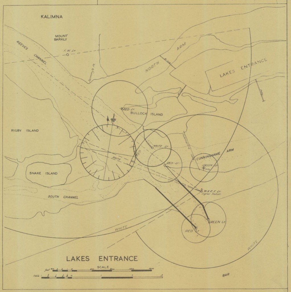
Plan of Proposed Entrance Waterway Works at Lakes Entrance c 1892
– Other Historical POI’s
– Museums
Discover Lakes Entrance:
– Shopping

IMG_0402

Highways-of-Water-039-Fixed-Small

Lakes-Entrance-081-Small

Highways-of-Water-009-Fixed-Small

Works-at-the-New-Entrance

Lakes-Entrance-Drawing

Entrance-Walk-181-Small

Entrance-Walk-106-Small

Entrance-Walk-107-Small

Entrance-Walk-110-Small

Entrance-Walk-121-Small

Entrance-Walk-128-Small

Entrance-Walk-130-Small

Entrance-Walk-135-Small

Entrance-Walk-139-Small

Entrance-Walk-140-Small

Entrance-Walk-147-Small

Entrance-Walk-162-Small

Entrance-Walk-167-Small

Entrance-Walk-170-Small

Entrance-Walk-173-Small

Entrance-Walk-177-Small
