Longitude: 150.574377 Latitude: -24.486412
Metres above Sea Level: 201.1 m
Area: 701 km² Perimeter: 168 km
View Thangool’s Statistics & Demographics
.
The first Europeans to traverse this area were the Archer Brothers during their tours of exploration radiating out from their Eidsvold run, which they had established in 1848:
” . . . Prior to 1852 Charles Archer had made several excursions to the Dawson waters, and in 1852 sent in applications for runs named Callide, Grevillea, Kariboe and Prospect – all names still in use, and which include the sites of the present towns of Biloela and Thangool . . . “
Source: Excerpt – ‘The Morning Bulletin’ – Article “The Fitzroy Valley: Centenary of Archers’ Discovery’ – published 7th May 1953
.
It was Dr. Ludwig Leichhardt who inspired Charles Archer to search further northward from Eidsvold:
” . . . The other arrival was Dr. Ludwig Leichhardt, who stayed with the Archers at Durundur for about eight months, studying the flora, fauna and geology of the surrounding country.
It was through letters received from Leichhardt after his return from Port Essington, in which he prophesied that the Dawson, Comet and Mackenzie rivers would all eventually join into one big river and would “disembogue”, as he called it, on the east coast, that made Charles later set out to find this river and the following year go out to the Peak Downs . . . “
Source: Excerpt – ‘The Morning Bulletin’ – Article “The Fitzroy Valley: Centenary of Archers’ Discovery’ – published 7th May 1953
.
Once the Archer Brothers had discovered and established their Gracemere run, situate just south-west of Rockhampton, c 1855, they transported their stock and supplies:
” . . . The last letter in the record is from Charles dated November 11, 1855, when he wrote:
“A practicable road was more easily discovered than I expected and the stock, drays, etc., reached Gracemere without loss or accident worth mentioning. As our ways and means were in a more flourishing state on this than any of our previous moves, a less stringent economy was practiced in fitting out the expedition, so that I travelled in comfort not usual on such occasions . . . “
” . . . Letters giving fuller details of the migration from Eidsvold to Gracemere have not been preserved . . . “
Source: Excerpts – ‘The Morning Bulletin’ – Article “The Fitzroy Valley: Centenary of Archers’ Discovery’ – published 7th May 1953
.
Though the trail northward had been carved, a township was not to evolve until the ‘Thangool Railway Station’ was established in 1924 – ‘Thangool’ meaning O’Possum in the Aboriginal Gangulu dialect.
The station was situate on a south-easterly branch of the ‘Callide Valley Line’, which runs from Rannes to Gladstone. The branch had originally been intended to run all the way to Monto, however, it was terminated just a short distance beyond Thangool.
The naming of the Railway Station occurred on the 2nd February 1924. Storekeepers soon began to move in around the station, the area was surveyed on the 17th July 1925, and so the township arose – and then blossomed – especially during the period of the 1930’s to 1950’s.
The following newspaper articles provide an insight into the Thangool of the 1930’s:
As reported in an article dated 27th October 1926, the railway department was already competing with evolution of the “Motor Traffic“:
” . . . Although the number of passenger journeys decreased by 1,273,530, the revenue was only £44,464 less than last year, showing that the average length of journeys increased, and the falling off took place principally in the shorter distance business . . . “
” . . . While a considerable proportion of the falling off was attributable to cessation of traffic during the railway strike, and to the drought prevailing, the rapid expansion of motor traffic is also responsible for loss of business to the railways . . . ”
Source: Excerpts – ‘The Brisbane Courier’ – Article ‘Deficit Doubled – Railway Revenue & Expenditure … ‘ – published 27th October 1926
The railway closed on the 31st January 1988.
Today, the township presents beautifully, the pride of the community emanates through the parks, gardens and reserves.
Surrounded by fields of both dry and irrigated crops – principally sorghum, wheat, sunflower, barley and mung beans as the dry crops – and – lucerne, navy & french beans as the irrigated crops – beef cattle being the main livestock – and of late, herbs are proving to be a great success.
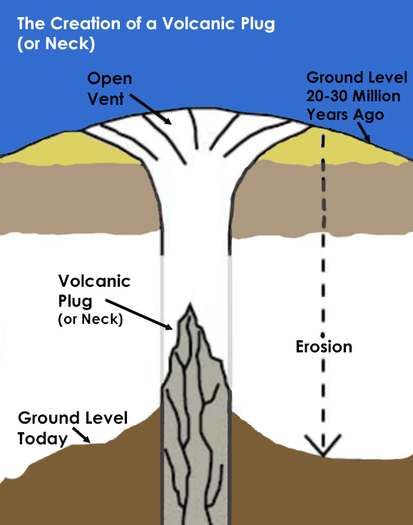 Some 7 km south of Thangool is the amazing natural phenomena that is, Mt. Scoria, often referred to as the ‘Musical Mountain’. This escarpment rises suddenly, some 150 m out of the surrounding flat landscape. Mt. Scoria is in fact a volcanic plug which was formed some 20–26 million years ago. A volcanic plug or lava neck, is formed when the lava within a vent of an active volcano cools and hardens. During this process, a plug can cause an extreme pressure build-up. Should the pressure of the magma beneath it become too great, it can lead to an explosive eruption, however, if the plug is preserved, and following some 20 million years of erosion, a Mount Scoria is formed, as the solidified lava plug is extremely durable and erosion resistant . . .
What makes Mount Scoria so unique, is the many sided, interlocking basalt columns that project outwards, most of which have 5 to 8 sides. These columns are believed to have been formed as a result of an eruption where the lava was unable to escape, but stayed within the crater where it cooled, forming a solid crust. The crust cracked as it shrank, the cracks became deeper as the deeper lava progressively cooled, producing these amazing columns. The music is created when tapping the columns with a rock – each column sounding its own unique tone . . .
.
Plan your trip to Thangool here
Discover Thangool via POI Australia’s Interactive Map, or, acquaint yourself with Thangool’s
– Shopping
– Services
.
.
Epilogue:
POI Australia has been designed to network Australia by encouraging and harnessing local knowledge wherever possible.
Our aim is to –
– encourage locals to support LOCAL community groups and events; and to use LOCAL products and services
– encourage visitors, tourists and investors to the many amazing regions of Australia that are so often overlooked.
During our visit, we have endeavoured to capture the essence of Thangool and collectively, with our research, have summarised the Points Of Interest (POI) that we have found.
We know that there are many more POI and stories to tell. We enthusiastically invite and encourage contributions to POI Australia – no matter how large or small. To submit information regarding your town and region, please contact us. The information will be reviewed, edited (to suit the segment), approved and added to POI Australia. Remember: “a picture says a thousand words” – so the more photos – the better. To maintain relevancy of the information on the website, we are always grateful to receive updates at any time.
We encourage community organisations, sporting clubs, events, non-for-profit organisations to list with us, as all these services are totally free of charge – apply for your 100% Discount Coupon here.
In order to maintain the free community services, POI Australia provides an opportunity for businesses to support their town and region by advertising for a nominal annual fee. The business listings are designed to be very quick and easy to complete, providing links to existing websites, Facebook, etc., so that time-poor business owners can quickly add and maintain their listings. We hope that the low charges will encourage business to “spread the word”.
The more we network, the more successful we will be in promoting Australia’s locations, stories, histories, businesses, people, sustainability and the environment.
Working together, we can protect our Country, our Environment and our Communities . . .

143

181b

146

185b

154b

191

178

142b
