Longitude: 152.278106 Latitude: -25.236226
Metres above Sea Level: 113.0 m
Area: 19 km² Perimeter: 31.2 km
View Childer’s Statistics & Demographics
.
Situate some 20 km (as the crow flies) inland from the coast, the historic township of Childers in Queensland, is beautifully positioned along the ridge of a hill, thereby bestowing the most magnificent views and horizons – every which way one glances . . . The green pastures; orchards; sugarcane fields – are dispersed across the rolling hills, and then POW !!! – a freshly cultivated field displays the most magnificent rich red soils !!! The sugarcane railway meanders through the countryside, the Kangaroos abound and quite unusually, but beautifully, many of the fields in the area remain unfenced.
The township of Childers is beautiful. Large shady trees line the streets. Historical buildings house the main shopping precinct demonstrating excellent examples of the diverse and beautiful architecture of the various periods of history. As one wanders through the town, it is quite apparent that many of the buildings tend to be of the early 1900’s era – only a few demonstrate the features of the 1800’s – a little further research and the reason becomes clear – a massive fire took much of the town in 1902 . . .
Today, the town is clean, beautifully kept with parks, gardens, interesting information signage, ample parking, provision for travellers – all within stunning surrounds.
The pride of the community can be felt everywhere.
This area was once known as the ‘Isis Scrub’, “Scrub” meaning ‘jungle’ in the early days . . . The scrub once covered some 25,000 acres. Today, the area is still distinctive due to its rich, red, fertile soil which runs to a depth of some 12 m. The beautiful soils are purported to be the result of the burning out of a volcano – ‘The Hummock’, located just to the east of Bundaberg, being the crater. As a result, sugarcane crops have prospered in the area for some 150 years.
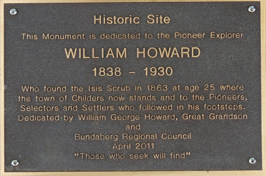 The ‘Isis Scrub’ is reported to have been discovered and explored by William Howard in 1863 – the dense jungle once comprised of Hoop Pine, of which many of the early buildings were constructed. Pioneer Park is dedicated to the Pioneers, Selectors and Settlers who tamed the land into the agricultural rolling hills we see today..
The land on which the township of Childers is situate was first selected by JE Noakes on the 23rd April 1878, noting that this is the ‘official’ date – often selectors had occupied the land for some 10 years before bureaucracy caught up.
On a journey from Maryborough in the early 1920’s, the following excerpt describes:
” . . . On the way there the train passes over a tract of very poor country and then suddenly it enters an extensive tract of rich, red basaltic soil, identical in quality with that of the Woongarra scrub, but differing from that in being entirely free from stones. Originally that Childers country was known as the “Isis Scrub,” being covered by a dense jungle, which was left undisturbed in the care of the birds and marsupials until there came the knowledge that the red volcanic scrub soil was among the richest in the State for sugar growing or general agriculture. The first selectors started clearing and burning off in 1871, and the following year the first cane was planted. There is a somewhat singular coincidence in the fact the Isis Scrub and the site of Childers are exactly the same height as the summit of the “Hummock” in the Woongarra Scrub. Each is just 350 ft. above sea level . . . “
Source: Excerpt – “The History of Queensland: Its People and Industries” by Matt. J. Fox – pp 822-823 – published 1923
As the pioneers moved in and the jungles were converted to agricultural fields, railways began to arrive:
“ . . . The Central Division railways were commenced in 1867, with thirty miles of line inland from the port of Rockhampton. In the ‘eighties a spurt of railway building connected the ports with the interior: e.g.: 1880, Townsville; 1881, Bundaberg; and Maryborough (to Gympie); 1885, Mackay; and Cooktown; 1887, Cairns; 1889, Normanton; and 1890, Bowen. In 1888, Maryborough had lines established to Bundaberg, Gympie, Childers, and Kilkivan, which were further connected to the Brisbane section in 1891 . . . “
Source: Excerpt – “Triumph in the Tropics” by Sir Raphael Cilento – pp 307-308 – published 1959
The Childers Railway link was opened on the 3rd October 1887, and from there, a town was born:
” . . . The town of Childers only dates back to 1892. It was laid out with wide streets, and the main street has a graceful curve and is beautified by avenues of trees on both sides. The very fertile soil encourages the rapid growth of all vegetation . . . “
” . . . In Childers there are three banks, six hotels, several good stores, a bi-weekly newspaper, motor garages, four churches, a Chamber of Commerce, four clubs, four lodges, two brass bands and two theatres. All the district is governed by the Isis Shire Council, which includes about 32,000 acres of good soil, of which the best 20,000 acres are under cane. The population of the Shire represents nearly 6,000 people . . . “
” . . . Far stretching fields of sugar cane extend over the long, graceful undulations of the cultivated red land which was once covered by the Isis Scrub, and cane fields continue for seven miles to Cordalba, on the line to Dallarnil, which is 38 miles beyond Childers . . . ”
Source: Excerpt – “The History of Queensland: Its People and Industries” by Matt. J. Fox – pp 822-823 – published 1923
” . . . Childers (pop. 1,500) is the principle town and the shire headquarters . . . “
Source: Excerpt – “Triumph in the Tropics” by Sir Raphael Cilento – pp 363 – published 1959
The railway was closed in 1964, however, some sections have been retained for the use of transporting sugarcane.
It seems strange that we, as Australians, all flock to the crowded oceans and waterways, when just a few kilometres inland, an absolute gem of a town can be discovered – with scarcely a tourist to be found ? Childers is an RV friendly town with ample parking for larger rigs. It attracts many international backpackers for the duration the harvest season . . .
Childers is well worth adding to your travel itinery !!!
.
Plan your trip to Childers here
Discover Childers via POI Australia’s Interactive Map, or, acquaint yourself with Childers‘
– Shopping
– Services
.
.
Epilogue:
POI Australia has been designed to network Australia by encouraging and harnessing local knowledge wherever possible.
Our aim is to –
– encourage locals to support LOCAL community groups and events; and to use LOCAL products and services
– encourage visitors, tourists and investors to the many amazing regions of Australia that are so often overlooked.
During our visit, we have endeavoured to capture the essence of Childers and collectively, with our research, have summarised the Points Of Interest (POI) that we have found.
We know that there are many more POI and stories to tell. We enthusiastically invite and encourage contributions to POI Australia – no matter how large or small. To submit information regarding your town and region, please contact us. The information will be reviewed, edited (to suit the segment), approved and added to POI Australia. Remember: “a picture says a thousand words” – so the more photos – the better. To maintain relevancy of the information on the website, we are always grateful to receive updates at any time.
We encourage community organisations, sporting clubs, events, non-for-profit organisations to list with us, as all these services are totally free of charge – apply for your 100% Discount Coupon here.
In order to maintain the free community services, POI Australia provides an opportunity for businesses to support their town and region by advertising for a nominal annual fee. The business listings are designed to be very quick and easy to complete, providing links to existing websites, Facebook, etc., so that time-poor business owners can quickly add and maintain their listings. We hope that the low charges will encourage business to “spread the word”.
The more we network, the more successful we will be in promoting Australia’s locations, stories, histories, businesses, people, sustainability and the environment.
Working together, we can protect our Country, our Environment and our Communities . . .

Childers3-119-b

Childers2-033-Butterfly

Childers3-060

Childers3-103

Childers3-004

Childers3-127

Childers3-162

Childers3-144

Childers3-152

Childers2-053

Childers3-171

Childers3-025-b

Childers2-001-b

Childers2-088
