The following excerpt of a transcription of Captain Cook’s Journal recording his voyage around the World in H.M. Bark ‘Endeavour’, describes his discoveries along the east coast of Australia, from Double Island Point to Bustard Bay during the period 18th May 1770 to 23rd May 1770, noting that any explanations added to the original text by the transcriber, are denoted in [brackets]:
” . . . Friday, 18th. In steering along shore at the distance of 2 Leagues off our Soundings was from 24 to 32 fathoms Sandy bottom. At 6 P.M. the North point set at Noon bore North 1/4 West; distant 4 Leagues; at 10 it bore North-West by West 1/2 West, and as we had seen no land to the Northward of it we brought too, not knowing which way to steer, having at this time but little wind, and continued so for the most part of the night. At 2 P.M. we made sail with the wind at South-West, and at daylight saw the land extending as far as North 3/4 East. The point set last night bore South-West by West, distant 3 or 4 Leagues; I have named it Double Island Point, on account of its figure (Latitude 25 degrees 58 minutes South, Longitude 206 degrees 48 minutes West). The land within this point is of a moderate and pretty equal height, but the point itself is of such an unequal Height that it looks like 2 Small Islands laying under the land; it likewise may be known by the white Cliffs on the North side of it. Here the land trends to the North-West, and forms a large open bay,* [* Wide Bay.] in the bottom of which the land appear’d to be very low, in so much that we could but just see it from the Deck. In crossing the mouth of this bay our Depth of Water was from 30 to 32 fathoms, a white sandy bottom. At Noon we were about 3 Leagues from the Land, and in the Latitude of 25 degrees 34 minutes South, Longitude 206 degrees 45 minutes West; Double Island Point bore South 3/4 West, and the Northermost land in sight North 3/4 East. The land hereabouts, which is of a moderate height, appears more barren than any we have yet seen on this Coast, and the Soil more sandy, there being several large places where nothing else is to be seen; in other places the woods look to be low and Shrubby, nor did we see many signs of inhabitants.
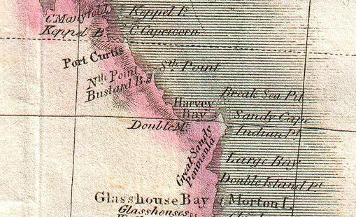
Excerpt – Map “New Holland & Asiatic Isles” for ‘Thomsons New General Atlas’ dated 1814
Saturday, 19th. In the P.M. had Variable light Airs, and Calms; in the night had a light breeze from the land, which in the A.M. veer’d to South-West and South-South-West. In the evening found the Variation to be 8 degrees 36 minutes East, and in the Morning 8 degrees 20 minutes; as we had but little wind we kept to the Northward all night, having from 23 to 27 fathoms fine sandy bottom, at the Distance of 2 or 3 Leagues from the Land. At Noon we were about 4 Miles from it, and by observation in the Latitude of 25 degrees 4 minutes, and in this situation had but 13 fathoms; the Northermost land in Sight bore North 21 degrees West, distant 8 Miles; our Course and distance sailed since yesterday at Noon was North 13 degrees 15 minutes East, 31 Miles.
[Off Sandy Cape, Queensland.]
Sunday, 20th. Winds Southerly, Gentle breezes. At 10 p.m. we passed, at the distance of 4 Miles, having 17 fathoms, a black bluff head or point of land, on which a number of the Natives were Assembled, which occasioned my naming it Indian Head; Latitude 25 degrees 0 minutes North by West, 4 Miles from this head, is another much like it. From this last the land Trends a little more to the Westward, and is low and Sandy next the Sea, for what may be behind it I know not; if land, it must be all low, for we could see no part of it from the Mast head. We saw people in other places besides the one I have mentioned; some Smokes in the day and fires in the Night. Having but little wind all Night, we kept on to the Northward, having from 17 to 34 fathoms, from 4 Miles to 4 Leagues from the Land, the Northermost part of which bore from us at daylight West-South-West, and seem’d to End in a point, from which we discover’d a Reef stretching out to the Northward as far as we could see, being, at this time, in 18 fathoms; for we had, before it was light, hauld our Wind to the Westward, and this course we continued until we had plainly discover’d breakers a long way upon our Lee Bow, which seem’d to Stretch quite home to the land. We then Edged away North-West and North-North-West, along the East side of the Shoal, from 2 to 1 Miles off, having regular, even Soundings, from 13 to 7 fathoms; fine sandy bottom. At Noon we were, by Observation, in the Latitude of 24 degrees 26 minutes South, which was 13 Miles to the Northward of that given by the Log. The extreme point of the Shoal we judged to bear about North-West of us; and the point of land above-mentioned bore South 3/4 West, distant 20 Miles. This point I have named Sandy Cape,* [* Sandy Cape is the northern point of Great Sandy Island. A long narrow channel separates the latter from the mainland, and opens at its northern end into Harvey Bay, a great sheet of water 40 miles across. This channel is now much used by the coasting trade, as it avoids the long detour round Breaksea Spit, a most dangerous shoal.] on account of 2 very large white Patches of Sand upon it. It is of a height Sufficient to be seen 12 Leagues in Clear weather (Latitude 24 degrees 46 minutes, Longitude 206 degrees 51 minutes West); from it the Land trends away West-South-West and South-West as far as we could see.
Monday, 21st. In the P.M. we kept along the East side of the Shoal until 2, when, judging there was water for us over, I sent a Boat a Head to sound, and upon her making the Signal for more than 5 fathoms we hauld our wind and stood over the Tail of it in 6 fathoms. At this time we were in the Latitude of 24 degrees 22 minutes South, and Sandy Cape bore South 1/2 East, distant 8 Leagues; but the Direction of the Shoal is nearest North-North-West and South-South-East. At this time we had 6 fathoms; the boat which was not above 1/4 of a mile to the Southward of us had little more than 5 fathoms. From 6 fathoms we had the next Cast, 13, and then 20 immediately, as fast as the Man could heave the Lead; from this I did suppose that the West side of the Shoal is pretty steep too, whereas on the other side we had gradual Soundings from 13 to 7 fathoms. This Shoal I called Break Sea Spit, because now we had smooth water, whereas upon the whole Coast to the Southward of it we had always a high Sea or swell from the South-East. At 6, the Land of Sandy Cape extending from South 17 degrees East to South 27 degrees East, distance 8 Leagues; Depth of Water, 23 fathoms, which depth we kept all Night, as we stood to the Westward with light Airs from the Southward; but between 12 and 4 A.M. we had it Calm, after which a Gentle breeze sprung up at South, with which we still kept on upon a Wind to the Westward. At 7 we Saw from the Masthead the Land of Sandy Cape bearing South-East 1/2 East, distance 12 or 13 Leagues. At 9, we discover’d from the Mast head land to the Westward, and soon after saw smoke upon it. Our depth of Water was now decreased to 17 fathoms, and by Noon to 13, at which time we were by observation in the Latitude of 24 degrees 28 minutes South, and about 7 Leagues from the Land, which extended from South by West to West-North-West. Longitude made from Sandy Cape 0 degrees 45 minutes West.
For these few days past we have seen at times a sort of Sea fowl we have no where seen before that I remember; they are of the sort called Boobies. Before this day we seldom saw more than 2 or 3 at a time, and only when we were near the land. Last night a small flock of these birds passed the Ship and went away to the North-West, and this morning from 1/2 an hour before sun rise to half an hour after, flights of them were continually coming from the North-North-West, and flying to the South-South-East, and not one was seen to fly in any other direction. From this we did suppose that there was a Lagoon, River, or Inlet of Shallow Water to the Southward of us, where these birds resorted to in the day to feed, and that not very far to the Northward lay some Island, where they retir’d too in the night.
Tuesday, 22nd. In the P.M. had a Gentle breeze at South-East, with which we stood in for the land South-West until 4, when, being in the Latitude of 24 degrees 36 minutes South, and about 2 Leagues from land, in 9 fathoms, we bore away along shore North-West by West; at the same time we could see the land extending to the South-South-East about 8 Leagues. Near the Sea the land is very low, but inland are some moderately high hills, and the whole appeared to be thickly Cloathed with wood. In running along shore we shoalded our Water from 9 to 7 fathoms, and at one time had but 6 fathoms, which determined me to Anchor for the Night, and accordingly at 8 o’Clock we came too in 8 fathoms, fine gravelly bottom, about 5 miles from the land. This evening we saw a Water Snake, and 2 or 3 evenings ago one lay under the Ship’s Stern some time; this was about 1 1/2 Yards in length, and was the first we had seen. At 6 A.M. weighed with a Gentle breeze Southerly, and Steer’d North-West 1/4 West, edging in for the land until we got Within 2 Miles of it, having from 7 to 11 fathoms; we then steer’d North-North-West as the land laid. At Noon we were by Observation in the Latitude of 24 degrees 19 minutes South; Longitude made from Sandy Cape 1 degree 14 minutes West.
[At Anchor. Bustard Bay, Queensland.]
Wednesday, 23rd. Continued our Course alongshore at the distance of about 2 Miles off, having from 12 to 9, 8 and 7 fathoms, until 5 o’Clock, at which time we were abreast of the South point of a Large open Bay,* [* Bustard Bay.] wherein I intended to Anchor. Accordingly we hauld in Close upon a Wind, and sent a boat ahead to sound; after making some Trips we Anchored at 8 o’Clock in 5 fathoms, a Sandy bottom. The South point of the bay bore East 3/4 South, distant 2 Miles; the North point North-West 1/4 North, about 2 Miles from the shore, in the bottom of the bay. Last night, some time in the Middle watch, a very extraordinary affair hapned to Mr. Orton, my Clerk. He having been drinking in the evening, some Malicious person or persons in the Ship took Advantage of his being Drunk, and cut off all the Cloaths from off his back; not being satisfied with this, they some time after went into his Cabin and cut off a part of both his Ears as he lay a Sleep in his Bed. The person whom he suspected to have done this was Mr. Magra, one of the Midshipmen; but this did not appear to me. Upon enquiry, however, as I had been told that Magra had once or twice before this in their drunken Frolicks cut off his cloaths, and had been heard to say (as I was told) that if it was not for the Law he would Murder him, these things consider’d, induced me to think that Magra was not Altogether innocent. I therefore for the present dismiss’d him the Quarter deck, and Suspended him from doing any duty in the Ship, he being one of those Gentlemen frequently found on board King’s Ships that can very well be spared; besides, it was necessary in me to show my immediate resentment against the person on whom the suspicion fell, least they should not have stop’d here. With respect to Mr. Orton, he is a man not without faults; yet from all the inquiry I could make, it evidently appear’d to me that so far from deserving such Treatment, he had not designed injuring any person in the Ship; so that I do—and shall always—look upon him as an injured man. Some reasons, however, might be given why this misfortune came upon him, in which he himself was in some measure to blame; but as this is only conjecture, and would tend to fix it upon some people in the Ship, whom I would fain believe would hardly be guilty of such an Action, I shall say nothing about it, unless I shall hereafter discover the Offenders, which I shall take every method in my power to do, for I look upon such proceedings as highly dangerous in such Voyages as this, and the greatest insult that could be offer’d to my Authority in this Ship, as I have always been ready to hear and redress every complaint that have been made against any Person in the Ship.* [* This history of Mr. Orton’s misadventure is omitted from the Admiralty copy. It is an illustration of the times to note that the fact of Orton having got drunk does not seem to call for the Captain’s severe censure. In these days, though the practical joker receives punishment, the drunkard would certainly come in for a large share also.] . . . “
Source: Excerpt – “Captain Cook’s Journal during his First Voyage Round the World made in H.M. Bark ‘Endeavour’ 1768-71 – A Literal Transcription of the Original MSS with Notes and Introduction by Captain W.J.L. Wharton, R.N., F.R.S. – Hydrographer of the Admiralty – Illustrated by Maps and Facsimiles” 1768-71 – published in 1893- 18th to 23rd May 1770
View other important events in this Region’s History . . .
View other important information on Discovering Terra Australis . . .
